IMAGES TAKEN NEAR TO
Hartlake Road, LONDON, E9 5BP
Introduction
This page details the photographs taken nearby to Hartlake Road, E9 5BP by members of the Geograph project.
The Geograph project started in 2005 with the aim of publishing, organising and preserving representative images for every square kilometre of Great Britain, Ireland and the Isle of Man.

There are currently over 7.5m images from over14,400 individuals and you can help contribute to the project by visiting https://www.geograph.org.uk
Image Map
Images are licensed for reuse under creativecommons.org/licenses/by-sa/2.0
Notes
- Clicking on the map will re-center to the selected point.
- The higher the marker number, the further away the image location is from the centre of the postcode.
Image Listing (83 Images Found)
Images are licensed for reuse under creativecommons.org/licenses/by-sa/2.0
Image
Details
Distance
1
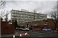
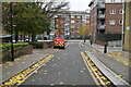
Flats, off Cassland Road, South Hackney
I can imagine what Prince Charles would have to say about these, and broadly speaking, I would agree with him.
Image: © Dr Neil Clifton
Taken: 24 Jan 2008
0.02 miles
2
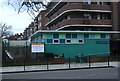
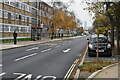
Wentworth Nursery and Children's Centre, Cassland Road
Image: © Jim Osley
Taken: 28 Jan 2011
0.06 miles
3
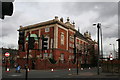
School, Cassland Road, South Hackney
Image: © Dr Neil Clifton
Taken: 24 Jan 2008
0.06 miles
6

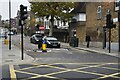
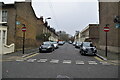
Christie Road, Homerton from Cassland Road
Image: © David Howard
Taken: 11 Jul 2012
0.09 miles
8
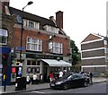
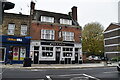
The Eagle, Public House, Homerton
On Wick Road.
Image: © David Anstiss
Taken: 26 Aug 2012
0.10 miles