IMAGES TAKEN NEAR TO
Cassland Road, LONDON, E9 5AJ
Introduction
This page details the photographs taken nearby to Cassland Road, E9 5AJ by members of the Geograph project.
The Geograph project started in 2005 with the aim of publishing, organising and preserving representative images for every square kilometre of Great Britain, Ireland and the Isle of Man.

There are currently over 7.5m images from over14,400 individuals and you can help contribute to the project by visiting https://www.geograph.org.uk
Image Map (85 Images)


Leaflet Map data © OpenStreetMap
Images are licensed for reuse under creativecommons.org/licenses/by-sa/2.0
Notes
- Clicking on the map will re-center to the selected point.
- The higher the marker number, the further away the image location is from the centre of the postcode.
Image Listing (85 Images Found)
Images are licensed for reuse under creativecommons.org/licenses/by-sa/2.0
Image
Details
Distance
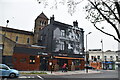
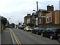
2
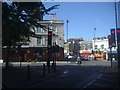
Cassland Road at the junction of Wick Road
Image: © David Howard
Taken: 11 Jul 2012
0.05 miles
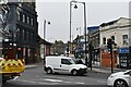
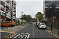
3
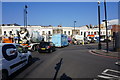
Traffic queuing to get onto Wick Road
The traffic is coming off Cassland Road which passes round the south side of Hackney town centre.
Image: © Bill Boaden
Taken: 17 Mar 2016
0.06 miles