
IMAGES TAKEN NEAR TO
Acton Mews, LONDON, E8 4EA
Introduction
This page details the photographs taken nearby to Acton Mews, E8 4EA by members of the Geograph project.
The Geograph project started in 2005 with the aim of publishing, organising and preserving representative images for every square kilometre of Great Britain, Ireland and the Isle of Man.

There are currently over 7.5m images from over14,400 individuals and you can help contribute to the project by visiting https://www.geograph.org.uk
Image Map
Images are licensed for reuse under creativecommons.org/licenses/by-sa/2.0
Notes
- Clicking on the map will re-center to the selected point.
- The higher the marker number, the further away the image location is from the centre of the postcode.
Image Listing (333 Images Found)
Images are licensed for reuse under creativecommons.org/licenses/by-sa/2.0
Image
Details
Distance
1

Overground train approaching Haggerston Station
Image: © Dillys Dad
Taken: 9 Nov 2025
0.01 miles

3

Tesco Express, Kingsland Road, London E8
Image: © Stacey Harris
Taken: 23 Jul 2010
0.02 miles

5

Lee Street, London
Another street off the east side of Kingsland Road, with refurbished bridge for the new London Overground
Image: © Dr Neil Clifton
Taken: 19 Jul 2007
0.03 miles


9

Haggerston station: Entrance from Lee Street
Station due to open June 2010: but may open earlier
Image: © Dr Neil Clifton
Taken: 25 Feb 2010
0.03 miles
10
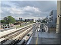
Haggerston railway station (site), London
Opened in 1867 by the North London Railway on the line from Broad Street to Dalston Junction, this station closed in 1940. It was rebuilt slightly to the north and reopened in 2010, this time on the East London Line from Dalston Junction to Clapham Junction via Rotherhithe.
View south towards Hoxton and Rotherhithe from the 2010 station. The former southbound platform of the 1867 station is on the left, covered by asphalt. All other traces have gone.
Image: © Nigel Thompson
Taken: 8 Jun 2010
0.03 miles