IMAGES TAKEN NEAR TO
Boleyn Road, LONDON, E7 9QD
Introduction
This page details the photographs taken nearby to Boleyn Road, E7 9QD by members of the Geograph project.
The Geograph project started in 2005 with the aim of publishing, organising and preserving representative images for every square kilometre of Great Britain, Ireland and the Isle of Man.

There are currently over 7.5m images from over14,400 individuals and you can help contribute to the project by visiting https://www.geograph.org.uk
Image Map (Loading...)


Getting Data...Please wait
Leaflet Map data © OpenStreetMap
Images are licensed for reuse under creativecommons.org/licenses/by-sa/2.0
Notes
- Clicking on the map will re-center to the selected point.
- The higher the marker number, the further away the image location is from the centre of the postcode.
Image Listing (33 Images Found)
Images are licensed for reuse under creativecommons.org/licenses/by-sa/2.0
Image
Details
Distance
1
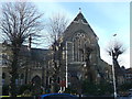
Church of St Antony's, Upton
Large grade II listed church on the junction of St Antony's Road and Lancaster Road.
See http://www.britishlistedbuildings.co.uk/en-204968-church-of-st-antony-and-monastery-greate for more details on the church.
Image: © David Anstiss
Taken: 16 Dec 2012
0.06 miles
2
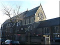
Church of St Antony's, Upton (2)
Large grade II listed church on the junction of St Antony's Road and Lancaster Road (in front).
See http://www.britishlistedbuildings.co.uk/en-204968-church-of-st-antony-and-monastery-greate for more details on the church.
Image: © David Anstiss
Taken: 16 Dec 2012
0.06 miles
4
St Bonaventure's Catholic School, Upton
On Lancaster Road.
Image: © David Anstiss
Taken: 16 Dec 2012
0.09 miles
5
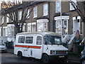
Old Bedford Ambulance
On Upton Park Road.
Built in 1981.
Image: © David Anstiss
Taken: 16 Dec 2012
0.10 miles
7
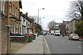
Plashet Road
Taken from outside the Sikh temple at the western end of the road, looking east.
Image: © Trevor Harris
Taken: 6 Feb 2016
0.10 miles
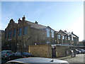
8
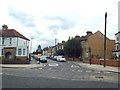
Boleyn Road, West Ham
Boleyn Road is a residential road in east London.
Image: © Malc McDonald
Taken: 3 Sep 2017
0.13 miles
9
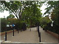
West Ham Park gate
This is one of several entrances to West Ham Park, in east London.
Image: © Malc McDonald
Taken: 3 Sep 2017
0.14 miles
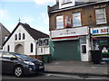
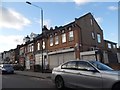
10
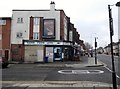
Nadir Food Ltd, Plashet Road E13
At the junction (and looking across) Churston Avenue
Image: © Robin Sones
Taken: 27 Feb 2013
0.15 miles