IMAGES TAKEN NEAR TO
Studley Road, LONDON, E7 9NX
Introduction
This page details the photographs taken nearby to Studley Road, E7 9NX by members of the Geograph project.
The Geograph project started in 2005 with the aim of publishing, organising and preserving representative images for every square kilometre of Great Britain, Ireland and the Isle of Man.

There are currently over 7.5m images from over14,400 individuals and you can help contribute to the project by visiting https://www.geograph.org.uk
Image Map (59 Images)


Getting Data...Please wait
Leaflet Map data © OpenStreetMap
Images are licensed for reuse under creativecommons.org/licenses/by-sa/2.0
Notes
- Clicking on the map will re-center to the selected point.
- The higher the marker number, the further away the image location is from the centre of the postcode.
Image Listing (59 Images Found)
Images are licensed for reuse under creativecommons.org/licenses/by-sa/2.0
Image
Details
Distance
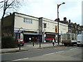
1
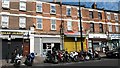
Motorcycle parking and shops on Upton Lane
Image: © David Martin
Taken: 10 Jul 2015
0.07 miles
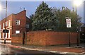
4
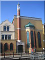
Forest Gate: Quwwat ul Islam Masjid, E7
The Quwwat ul Islam Masjid (Might of Islam Mosque) can be found on the west side of Upton Lane.
Image: © Nigel Cox
Taken: 15 Mar 2007
0.09 miles
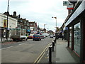
5
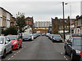
Vale Road, Forest Gate
Looking towards Upton Lane in the less fashionable part of Forest Gate.
Image: © Stephen McKay
Taken: 28 Oct 2016
0.10 miles
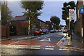
7
Green Street at the corner of Finden Road
Image: © David Howard
Taken: 23 Oct 2022
0.11 miles
8
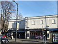
The Hudson Bay, Public House, Forest Gate
Wetherspoons pub on Upton Lane.
Image: © David Anstiss
Taken: 16 Dec 2012
0.13 miles
9
The Hudson Bay public house, Forest Gate
Image: © Stacey Harris
Taken: 22 Mar 2010
0.13 miles
10
Emmanuel, Forest Gate - War Memorial WWII
Image: © John Salmon
Taken: 2 Oct 2014
0.14 miles