IMAGES TAKEN NEAR TO
Dunbar Road, LONDON, E7 9NH
Introduction
This page details the photographs taken nearby to Dunbar Road, E7 9NH by members of the Geograph project.
The Geograph project started in 2005 with the aim of publishing, organising and preserving representative images for every square kilometre of Great Britain, Ireland and the Isle of Man.

There are currently over 7.5m images from over14,400 individuals and you can help contribute to the project by visiting https://www.geograph.org.uk
Image Map (Loading...)


Getting Data...Please wait
Leaflet Map data © OpenStreetMap
Images are licensed for reuse under creativecommons.org/licenses/by-sa/2.0
Notes
- Clicking on the map will re-center to the selected point.
- The higher the marker number, the further away the image location is from the centre of the postcode.
Image Listing (55 Images Found)
Images are licensed for reuse under creativecommons.org/licenses/by-sa/2.0
Image
Details
Distance
1
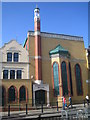
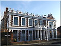
Forest Gate: Quwwat ul Islam Masjid, E7
The Quwwat ul Islam Masjid (Might of Islam Mosque) can be found on the west side of Upton Lane.
Image: © Nigel Cox
Taken: 15 Mar 2007
0.05 miles
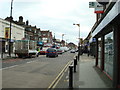
3
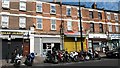
Motorcycle parking and shops on Upton Lane
Image: © David Martin
Taken: 10 Jul 2015
0.07 miles
4
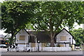
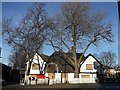
Derelict pub is part of football history
It was in 1888 that Clapton FC began playing at the ground which took its name from this now derelict pub - the Old Spotted Dog. Over 80 years ago, Clapton were one of England's most powerful amateur sides winning the prestigious F.A. Amateur Cup five times. The pub in Upton Lane, near Forest Gate station, has been boarded up for several years.
Image: © David Williams
Taken: 13 Jun 2014
0.09 miles
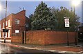
5
Red House, Upton
Grade II listed house on Upton Avenue.
It was once a Dutch merchant's home, then the home of Mr Tuthill, the manufacturer of early trade union banners and in 1933 it became St. Anthony's Catholic Club. It has been recently converted back to a house.
See http://www.britishlistedbuildings.co.uk/en-469074-red-house-greater-london-authority for more details on the house.
Image: © David Anstiss
Taken: 16 Dec 2012
0.09 miles
6
The Spotted Dog Public House, Upton (2)
The sadly closed, Grade II listed public house on the bend on Upton Lane.
See http://www.britishlistedbuildings.co.uk/en-204975-the-spotted-dog-public-house-greater-lon for more details on the pub.
Image: © David Anstiss
Taken: 16 Dec 2012
0.11 miles
7
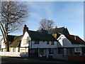
The Spotted Dog Public House, Upton
The sadly closed, Grade II listed public house on the bend on Upton Lane.
See http://www.britishlistedbuildings.co.uk/en-204975-the-spotted-dog-public-house-greater-lon for more details on the pub.
Image: © David Anstiss
Taken: 16 Dec 2012
0.11 miles
8
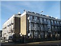
Apartment block on Upton Lane
This looks like a converted warehouse converted into a large block of apartments.
Image: © David Anstiss
Taken: 16 Dec 2012
0.13 miles
10
Green Street at the corner of Finden Road
Image: © David Howard
Taken: 23 Oct 2022
0.19 miles