IMAGES TAKEN NEAR TO
Romford Road, LONDON, E7 9HL
Introduction
This page details the photographs taken nearby to Romford Road, E7 9HL by members of the Geograph project.
The Geograph project started in 2005 with the aim of publishing, organising and preserving representative images for every square kilometre of Great Britain, Ireland and the Isle of Man.

There are currently over 7.5m images from over14,400 individuals and you can help contribute to the project by visiting https://www.geograph.org.uk
Image Map (Loading...)


Getting Data...Please wait
Leaflet Map data © OpenStreetMap
Images are licensed for reuse under creativecommons.org/licenses/by-sa/2.0
Notes
- Clicking on the map will re-center to the selected point.
- The higher the marker number, the further away the image location is from the centre of the postcode.
Image Listing (27 Images Found)
Images are licensed for reuse under creativecommons.org/licenses/by-sa/2.0
Image
Details
Distance
3
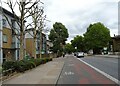
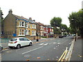
Knox Road, near Forest gate
Knox Road is a residential road in the suburbs of east London.
Image: © Malc McDonald
Taken: 3 Sep 2017
0.13 miles
4
Norwich Road, near Forest Gate
Norwich Road is a tree-lined residential road near Forest Gate, in the suburbs of east London.
Image: © Malc McDonald
Taken: 3 Sep 2017
0.14 miles
5
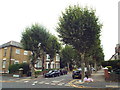
Earlham Grove, near Forest Gate
Earlham Grove is a tree-lined residential road near Forest Gate, in the east London suburbs.
Image: © Malc McDonald
Taken: 3 Sep 2017
0.15 miles
6
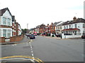
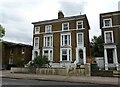
Margery Park Road, near Forest Gate
Margery park Road is a residential road in the east London suburbs.
Image: © Malc McDonald
Taken: 3 Sep 2017
0.19 miles
7
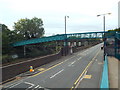
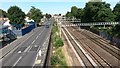
Bridge over Forest lane, near Forest Gate
This footbridge crosses Forest Lane, and the railway line immediately adjacent.
The railway forms part of the Great Eastern Main Line, linking London with Colchester, Ipswich and Norwich.
Image: © Malc McDonald
Taken: 3 Sep 2017
0.21 miles
8
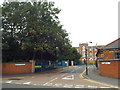
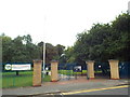
Magpie Close, near Forest Gate
The curved walls at the entrance to Magpie Close suggest that this was once the gateway to the large building in the background.
The building was originally a school for poor children, opened in the 1850s. It subequently became a workhouse, then a hospital, closing in the 1980s. Housing and a park have since been developed on the grounds, and the building is now just a facade.
More information can be found on the London Gardens Online website: http://www.londongardensonline.org.uk/gardens-online-record.php?ID=NEW012
Image: © Malc McDonald
Taken: 3 Sep 2017
0.21 miles
9
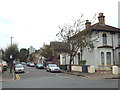
Road and rail near Forest Gate station
Image: © David Martin
Taken: 10 Jul 2015
0.21 miles
10
Forest Lane Park, near Forest Gate
An entrance to Forest lane park, on Magpie Close.
The park was developed on part of a former hospital site. More information is on the London Gardens online website: http://www.londongardensonline.org.uk/gardens-online-record.php?ID=NEW012
Image: © Malc McDonald
Taken: 3 Sep 2017
0.22 miles