IMAGES TAKEN NEAR TO
St. Georges Road, LONDON, E7 8HU
Introduction
This page details the photographs taken nearby to St. Georges Road, E7 8HU by members of the Geograph project.
The Geograph project started in 2005 with the aim of publishing, organising and preserving representative images for every square kilometre of Great Britain, Ireland and the Isle of Man.

There are currently over 7.5m images from over14,400 individuals and you can help contribute to the project by visiting https://www.geograph.org.uk
Image Map (Loading...)


Getting Data...Please wait
Leaflet Map data © OpenStreetMap
Images are licensed for reuse under creativecommons.org/licenses/by-sa/2.0
Notes
- Clicking on the map will re-center to the selected point.
- The higher the marker number, the further away the image location is from the centre of the postcode.
Image Listing (13 Images Found)
Images are licensed for reuse under creativecommons.org/licenses/by-sa/2.0
Image
Details
Distance
1
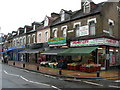
Shops on Green Street, E7
These shops are on the corner of Green Street and St George's Road, E7
Image: © Danny P Robinson
Taken: 13 May 2007
0.10 miles
2
Muslim Community Centre and Mosque, Forest Gate
This Muslim Community Centre and Mosque is at 88 Green Street, E7 8JG, on the corner with Studley Road.
Image: © Danny P Robinson
Taken: 13 May 2007
0.11 miles
3
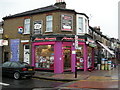
Asian Music Shop on Green Street
This shop is on the corner of Green Street and Halley Road, E7. There is a large Asian population in this area, and for those who live outside the area it is also a traditional place to come shopping. There are even coach parties.
Image: © Danny P Robinson
Taken: 13 May 2007
0.14 miles
4
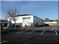
Elmhurst Primary School, Upton
Large Primary school, between Upton Park Road and Elmhurst Road.
Image: © David Anstiss
Taken: 16 Dec 2012
0.15 miles
5
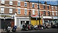
Motorcycle parking and shops on Upton Lane
Image: © David Martin
Taken: 10 Jul 2015
0.16 miles
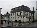
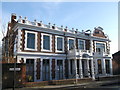
8
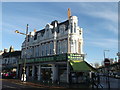
Khana Khazana Restaurant, Upton
Ornate building on the junction of Green Street and Woodstock Road (on the right).
Image: © David Anstiss
Taken: 16 Dec 2012
0.17 miles
9
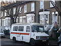
Old Bedford Ambulance
On Upton Park Road.
Built in 1981.
Image: © David Anstiss
Taken: 16 Dec 2012
0.21 miles
10
Red House, Upton
Grade II listed house on Upton Avenue.
It was once a Dutch merchant's home, then the home of Mr Tuthill, the manufacturer of early trade union banners and in 1933 it became St. Anthony's Catholic Club. It has been recently converted back to a house.
See http://www.britishlistedbuildings.co.uk/en-469074-red-house-greater-london-authority for more details on the house.
Image: © David Anstiss
Taken: 16 Dec 2012
0.23 miles