IMAGES TAKEN NEAR TO
Bronte Close, LONDON, E7 0EJ
Introduction
This page details the photographs taken nearby to Bronte Close, E7 0EJ by members of the Geograph project.
The Geograph project started in 2005 with the aim of publishing, organising and preserving representative images for every square kilometre of Great Britain, Ireland and the Isle of Man.

There are currently over 7.5m images from over14,400 individuals and you can help contribute to the project by visiting https://www.geograph.org.uk
Image Map (Loading...)


Getting Data...Please wait
Leaflet Map data © OpenStreetMap
Images are licensed for reuse under creativecommons.org/licenses/by-sa/2.0
Notes
- Clicking on the map will re-center to the selected point.
- The higher the marker number, the further away the image location is from the centre of the postcode.
Image Listing (37 Images Found)
Images are licensed for reuse under creativecommons.org/licenses/by-sa/2.0
Image
Details
Distance
1
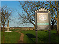
Wanstead Flats
The southern end of Epping forest marked by this City of London information board.
Image: © Stephen McKay
Taken: 23 Dec 2015
0.04 miles
2
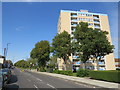
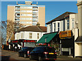
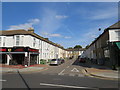
Woodford Road and Capel Point, Forest Gate
Woodford Road is a suburban A road in east London.
Image: © Malc McDonald
Taken: 10 Sep 2020
0.04 miles
3
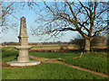
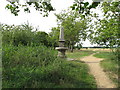
Joseph Fry Drinking Fountain, Wanstead Flats
The fountain at the southern end of Wanstead Flats was erected in memory of Joseph Fry (1809-1896) who had organised the construction of many drinking fountains, for people and horses, around London.
Image: © Stephen McKay
Taken: 23 Dec 2015
0.04 miles
4
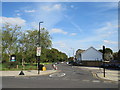
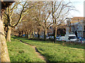
Capel Road, Forest Gate
Capel Road is a residential road along the southern edge of Wanstead Flats in the suburbs of east London.
Image: © Malc McDonald
Taken: 10 Sep 2020
0.04 miles
6
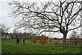
South western corner of Wanstead Flats
Taken from Capel Road looking towards Woodford Road.
Image: © Trevor Harris
Taken: 12 Dec 2020
0.05 miles
7
Woodford Road, Forest Gate
Woodford Road leads north towards Forest Gate overlooked by Capel Point. Curwen Avenue leads off by the Tyre Centre.
Image: © Stephen McKay
Taken: 23 Dec 2015
0.07 miles
8
Capel Road, Forest Gate
The southern edge of Wanstead Flats.
Image: © Stephen McKay
Taken: 23 Dec 2015
0.08 miles
9
Curwen Avenue, Forest Gate
Curwen Avenue is a short residential cul-de-sac in Forest Gate in the suburbs of east London.
Image: © Malc McDonald
Taken: 10 Sep 2020
0.08 miles
10
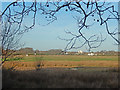
Angel Pond, Wanstead Flats
Angel (or, more correctly Angell) Pond was named after Lewis Angell, the first borough engineer of West Ham. It is not really much of a pond, more an area of boggy ground even in this winter view. Wanstead Flats is the most southerly part of Epping Forest.
Image: © Stephen McKay
Taken: 23 Dec 2015
0.08 miles