IMAGES TAKEN NEAR TO
Vansittart Road, LONDON, E7 0AS
Introduction
This page details the photographs taken nearby to Vansittart Road, E7 0AS by members of the Geograph project.
The Geograph project started in 2005 with the aim of publishing, organising and preserving representative images for every square kilometre of Great Britain, Ireland and the Isle of Man.

There are currently over 7.5m images from over14,400 individuals and you can help contribute to the project by visiting https://www.geograph.org.uk
Image Map (Loading...)


Getting Data...Please wait
Leaflet Map data © OpenStreetMap
Images are licensed for reuse under creativecommons.org/licenses/by-sa/2.0
Notes
- Clicking on the map will re-center to the selected point.
- The higher the marker number, the further away the image location is from the centre of the postcode.
Image Listing (15 Images Found)
Images are licensed for reuse under creativecommons.org/licenses/by-sa/2.0
Image
Details
Distance
1
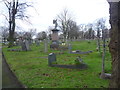
Entrance to West Ham Cemetery
West Ham Cemetery was established by the West Ham Burial Board in 1857 and was extended in 1871. Good drainage and low cost were considered more important than the landscape potential when the land was purchased. As a result the cemetery is rather lacking in distinctive features and has a straightforward grid of paths.
This is the entrance in Cemetery Road.
Image: © Marathon
Taken: 14 Jan 2015
0.14 miles
2
West Ham Cemetery
West Ham Cemetery was established by the West Ham Burial Board in 1857 and was extended in 1871. Good drainage and low cost were considered more important than the landscape potential when the land was purchased. As a result the cemetery is rather lacking in distinctive features and has a straightforward grid of paths.
Image: © Marathon
Taken: 14 Jan 2015
0.14 miles
3
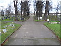
Looking towards the war memorial at West Ham Cemetery
West Ham Cemetery was established by the West Ham Burial Board in 1857 and was extended in 1871. Good drainage and low cost were considered more important than the landscape potential when the land was purchased. As a result the cemetery is rather lacking in distinctive features and has a straightforward grid of paths.
There is just the one entrance - in Cemetery Road. This is near the far end, looking along a line of lime trees towards the war memorial.
Image: © Marathon
Taken: 14 Jan 2015
0.15 miles
4
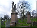
Ling family memorial, West Ham Cemetery
West Ham Cemetery was established by the West Ham Burial Board in 1857 and was extended in 1871. Good drainage and low cost were considered more important than the landscape potential when the land was purchased. As a result the cemetery is rather lacking in distinctive features and has a straightforward grid of paths.
This monument is to William Ling ("founder of W.Ling Ltd") who died May 27th 1925 aged 82 and also to his wife Elizabeth who died 31st March 1911 aged 67. On the side nearest the photograph are commemorated their children who mostly died young. They were Elizabeth Selina died 10th February 1875 aged 20 months, William died 17th April 1877 aged 16 months, and William, John died 22nd October 1879 aged 19 months. Also included is "their beloved daughter Sarah Ann Robins" who died on Christmas Day 1924 aged 52.
It is clear that looking at the ages of the children the father wanted his eldest son to be called William like himself and when the first son called William, died in 1877 the next son born a year later was also called William. Sadly he fared little better, dying 19 months later.
Image: © Marathon
Taken: 14 Jan 2015
0.16 miles
5
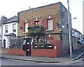
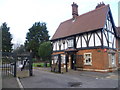
A distinctive house in Pevensey Road
This house is on the corner of Pevensey Road and Hesketh Road. It is fortunate that there is an outside post box as there are at least six notices on the front, warning of dogs.
Image: © Marathon
Taken: 14 Jan 2015
0.17 miles
6
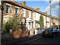
An archetypal east London terrace
Trumpington Road, E11
Image: © John Davies
Taken: 20 Jan 2006
0.22 miles
7
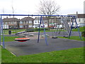
Playground seen from Odessa Road
This small playground and green space lies between Odessa Road and Wellington Road.
Image: © Marathon
Taken: 14 Jan 2015
0.22 miles
8
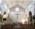
St Saviour, MacDonald Road, Forest Gate - East end
Image: © John Salmon
Taken: 23 Nov 2017
0.24 miles
9

St Saviour, MacDonald Road, Forest Gate - West end
Image: © John Salmon
Taken: 23 Nov 2017
0.24 miles
10
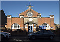
St Saviour, MacDonald Road, Forest Gate
Was the church hall, consecrated in 1977.
Image: © John Salmon
Taken: 23 Nov 2017
0.24 miles