IMAGES TAKEN NEAR TO
High Street South, LONDON, E6 6DY
Introduction
This page details the photographs taken nearby to High Street South, E6 6DY by members of the Geograph project.
The Geograph project started in 2005 with the aim of publishing, organising and preserving representative images for every square kilometre of Great Britain, Ireland and the Isle of Man.

There are currently over 7.5m images from over14,400 individuals and you can help contribute to the project by visiting https://www.geograph.org.uk
Image Map
Images are licensed for reuse under creativecommons.org/licenses/by-sa/2.0
Notes
- Clicking on the map will re-center to the selected point.
- The higher the marker number, the further away the image location is from the centre of the postcode.
Image Listing (47 Images Found)
Images are licensed for reuse under creativecommons.org/licenses/by-sa/2.0
Image
Details
Distance
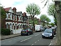
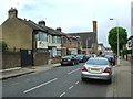
3
Central Park, East Ham
The land was obtained in 1896 by East Ham District Council to create a park in the centre of the growing town. It had previously been the grounds of Rancliffe House, an early 18th century house which was demolished in 1908. The park was later extended to its present size by further land purchases.
The town's monument to 1,824 East Ham residents killed in the First World War stands in the park. It was unveiled in 1921 - see http://www.geograph.org.uk/photo/4380879 This view looks along the eastern boundary of the park with High Street South to the right.
Image: © Marathon
Taken: 10 Mar 2015
0.04 miles
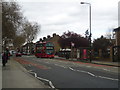
6
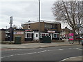
The White Horse public house, East Ham
Image: © Stacey Harris
Taken: 31 Mar 2012
0.05 miles
8
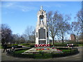
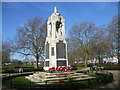
East Ham War Memorial, Central Park
The land was obtained in 1896 by East Ham District Council to create a park in the centre of the growing town. It had previously been the grounds of Rancliffe House, an early 18th century house which was demolished in 1908. The park was later extended to its present size by further land purchases.
The town's monument to 1,824 East Ham residents killed in the First World War stands in the park and is seen here. Former East Ham Mayor Mr Banks-Martin was the architect of the war memorial. It was unveiled in 1921.
Image: © Marathon
Taken: 10 Mar 2015
0.06 miles
9
East Ham War Memorial in Central Park
The land was obtained in 1896 by East Ham District Council to create a park in the centre of the growing town. It had previously been the grounds of Rancliffe House, an early 18th century house which was demolished in 1908. The park was later extended to its present size by further land purchases.
The town's monument to 1,824 East Ham residents killed in the First World War stands in the park and is seen here. Former East Ham Mayor Mr Banks-Martin was the architect of the war memorial. It was unveiled in 1921.
Image: © Marathon
Taken: 10 Mar 2015
0.06 miles
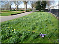
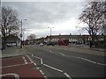
10
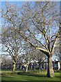
Path in Central Park, East Ham
This path leads around the war memorial towards High Street.
Image: © David Anstiss
Taken: 16 Dec 2012
0.07 miles