IMAGES TAKEN NEAR TO
York Close, LONDON, E6 5QN
Introduction
This page details the photographs taken nearby to York Close, E6 5QN by members of the Geograph project.
The Geograph project started in 2005 with the aim of publishing, organising and preserving representative images for every square kilometre of Great Britain, Ireland and the Isle of Man.

There are currently over 7.5m images from over14,400 individuals and you can help contribute to the project by visiting https://www.geograph.org.uk
Image Map (Loading...)


Getting Data...Please wait
Leaflet Map data © OpenStreetMap
Images are licensed for reuse under creativecommons.org/licenses/by-sa/2.0
Notes
- Clicking on the map will re-center to the selected point.
- The higher the marker number, the further away the image location is from the centre of the postcode.
Image Listing (63 Images Found)
Images are licensed for reuse under creativecommons.org/licenses/by-sa/2.0
Image
Details
Distance
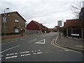
1

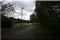
Path in East New Beckton Park
This small recreational ground is near New Beckton Park.
The path is also used by the long distance path (Capital Ring) heading towards Beckton District Park.
Image: © David Anstiss
Taken: 26 Aug 2012
0.02 miles

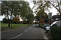
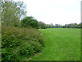
3

Beckton District South Park
Beckton District Park was landscaped during the late 1970s and early 1980s in an irregular shape between new housing developments. The park opened in 1982. This view is near the southern end. The houses are in Parry Avenue.
Image: © Marathon
Taken: 20 Apr 2012
0.04 miles
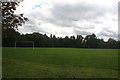
7
Beckton District South Park
Beckton District Park was landscaped during the late 1970s and early 1980s in an irregular shape between new housing developments. The park opened in 1982. This view is near the southern end.
Image: © Marathon
Taken: 20 Apr 2012
0.08 miles
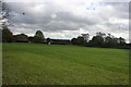
8
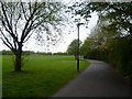
Capital Ring in Beckton District South Park
Beckton District Park was landscaped during the late 1970s and early 1980s in an irregular shape between new housing developments. The park opened in 1982. This view is near the southern end and shows part of the Capital Ring on its 78 mile route around inner London.
Image: © Marathon
Taken: 20 Apr 2012
0.08 miles