IMAGES TAKEN NEAR TO
Stokes Road, LONDON, E6 3SF
Introduction
This page details the photographs taken nearby to Stokes Road, E6 3SF by members of the Geograph project.
The Geograph project started in 2005 with the aim of publishing, organising and preserving representative images for every square kilometre of Great Britain, Ireland and the Isle of Man.

There are currently over 7.5m images from over14,400 individuals and you can help contribute to the project by visiting https://www.geograph.org.uk
Image Map
Images are licensed for reuse under creativecommons.org/licenses/by-sa/2.0
Notes
- Clicking on the map will re-center to the selected point.
- The higher the marker number, the further away the image location is from the centre of the postcode.
Image Listing (59 Images Found)
Images are licensed for reuse under creativecommons.org/licenses/by-sa/2.0
Image
Details
Distance
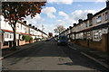
2
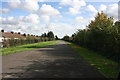
Greenway heading east
Along the Northern Outfall Sewer towards Beckton.
Image: © Robin Webster
Taken: 11 Dec 2010
0.04 miles
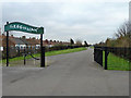
4
Ramp down from Greenway to Stokes Road, E6
There are also steps taking a shorter route.
Image: © Robin Webster
Taken: 11 Dec 2010
0.05 miles
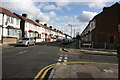
9
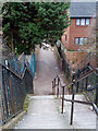
Steps down from Greenway to Stokes Road, E6
There is alternatively a ramp for those who can't manage these.
Image: © Robin Webster
Taken: 11 Dec 2010
0.06 miles
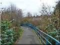
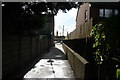
10
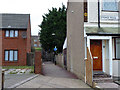
Path up to Greenway from Stokes Road, E6
There is an alternative ramp off right from the foot of the steps.
Image: © Robin Webster
Taken: 11 Dec 2010
0.07 miles