IMAGES TAKEN NEAR TO
Lonsdale Avenue, LONDON, E6 3QA
Introduction
This page details the photographs taken nearby to Lonsdale Avenue, E6 3QA by members of the Geograph project.
The Geograph project started in 2005 with the aim of publishing, organising and preserving representative images for every square kilometre of Great Britain, Ireland and the Isle of Man.

There are currently over 7.5m images from over14,400 individuals and you can help contribute to the project by visiting https://www.geograph.org.uk
Image Map
Images are licensed for reuse under creativecommons.org/licenses/by-sa/2.0
Notes
- Clicking on the map will re-center to the selected point.
- The higher the marker number, the further away the image location is from the centre of the postcode.
Image Listing (78 Images Found)
Images are licensed for reuse under creativecommons.org/licenses/by-sa/2.0
Image
Details
Distance
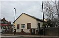
1
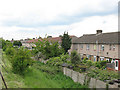
Houses alongside the Greenway
The backs of houses on Lonsdale Avenue, see from the Greenway (the fence of which can just be seen in the corner of the photo).
Image: © Stephen Craven
Taken: 15 May 2010
0.03 miles
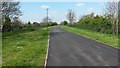
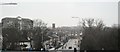
3
The Greenway at East Ham
By the 1850s the River Thames in Central London was a vast open sewer and “The Great Stink” of 1855 brought matters to a head. The smell was so strong that curtains soaked in calcium chloride had to be hung over the windows of the Houses of Parliament facing the river. The Government finally acknowledged the problem and established the Metropolitan Board of Works. Their first task was the provision of a proper sewerage and drainage system. The Northern and Southern Outfall Sewers were constructed between 1860 and 1865, the former carrying sewage from northern London to the Northern Outfall Works at Beckton.
The Greenway has been opened up on top as a footway and cycle track and runs all the way from Victoria Park to Beckton. The Capital Ring follows most of it. Here it is seen from near High Street South, with Lonsdale Avenue to the right.
Image: © Marathon
Taken: 10 Mar 2015
0.06 miles
4
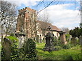
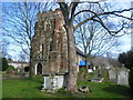
East Ham: Church of St Mary Magdalene
There has reputedly been a church on this site since before the Norman Conquest of 1066 although the present church is thought to date from no earlier than the first half of the 12th century. The tower probably dates from the early 13th century, but has been much restored. The church suffered from bomb damage in 1941, including the loss of all of its stained glass windows.
The churchyard covers an area of about 9.5 acres but has recently been closed for burials. Since 1977 most of the churchyard has been left as a nature reserve, managed by the London Borough of Newham as East Ham Nature Reserve, although this area around the church is maintained for worshippers and weddings. The flag of St George is fluttering from the flagstaff on the tower.
Image: © Nigel Cox
Taken: 10 Apr 2008
0.07 miles
7
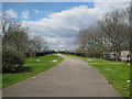
East Ham: The Greenway and the Northern Outfall Sewer
The Greenway has been created as a linear footpath and cycleway along the top of the embankment of the Northern Outfall Sewer. The sewer was built between 1860 and 1865 under the direction of Joseph Bazalgette for the Metropolitan Commissioners for Sewers at a cost of £164,000, and was designed to remove sewage from North London to Beckton. By the 1850s the River Thames in central London was effectively an open sewer since sewage drained directly into it. The 'Great Stink' of 1855 caused Parliament and the Law Courts to seriously consider moving away from the river. The Metropolitan Board of Works was set up in 1855, with the construction of a sewage system as its primary task.
Image: © Nigel Cox
Taken: 10 Apr 2008
0.08 miles
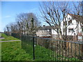
8
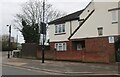
Lonsdale Avenue, East Ham
At the corner of High Street South.
Image: © David Howard
Taken: 13 Mar 2022
0.08 miles
9
St Mary Magdalene Churchyard, East Ham
St Mary Magdalene has possibly London's largest churchyard. St Mary Magdalene is one of the very few scarcely altered Norman churches to be found in the London area. The body of the church dates from about 1130, although Roman bricks are used in the construction alongside Norman pudding stone. The upper part of the tower dates from the 16th Century.
The churchyard is managed as a nature reserve by Newham Council and includes a visitor centre, built in 1981 and which was formally opened by the Queen in 1983. The visitor centre includes a classroom and a small museum display. The churchyard is known as East Ham Nature Reserve and was used as a model for the National Churchyard Conservation Campaign, which was launched here in 1991. The oldest part of the churchyard, around the church, is kept neat and tidy but much of the rest towards the south and east has been allowed to turn into woodland.
Image: © Marathon
Taken: 10 Mar 2015
0.09 miles
10

St Mary Magdalene Churchyard, East Ham
St Mary Magdalene has possibly London's largest churchyard. St Mary Magdalene is one of the very few scarcely altered Norman churches to be found in the London area. The body of the church dates from about 1130, although Roman bricks are used in the construction alongside Norman pudding stone. The upper part of the tower dates from the 16th Century. The churchyard is managed as a nature reserve by Newham Council and includes a visitor centre, built in 1981 and which was formally opened by the Queen in 1983. The visitor centre includes a classroom and a small museum display. The churchyard is known as East Ham Nature Reserve and was used as a model for the National Churchyard Conservation Campaign, which was launched here in 1991. The oldest part of the churchyard, around the church, is kept neat and tidy but much of the rest towards the south and east has been allowed to turn into woodland.
Image: © Marathon
Taken: 10 Mar 2015
0.09 miles