IMAGES TAKEN NEAR TO
Brooks Avenue, LONDON, E6 3PQ
Introduction
This page details the photographs taken nearby to Brooks Avenue, E6 3PQ by members of the Geograph project.
The Geograph project started in 2005 with the aim of publishing, organising and preserving representative images for every square kilometre of Great Britain, Ireland and the Isle of Man.

There are currently over 7.5m images from over14,400 individuals and you can help contribute to the project by visiting https://www.geograph.org.uk
Image Map
Images are licensed for reuse under creativecommons.org/licenses/by-sa/2.0
Notes
- Clicking on the map will re-center to the selected point.
- The higher the marker number, the further away the image location is from the centre of the postcode.
Image Listing (74 Images Found)
Images are licensed for reuse under creativecommons.org/licenses/by-sa/2.0
Image
Details
Distance
5
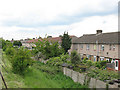
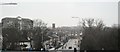
Houses alongside the Greenway
The backs of houses on Lonsdale Avenue, see from the Greenway (the fence of which can just be seen in the corner of the photo).
Image: © Stephen Craven
Taken: 15 May 2010
0.09 miles
7
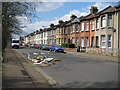
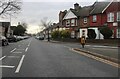
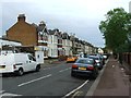
East Ham: Norman Road, E6
This pleasant row of three bedroomed Victorian terraced housing overlooks Image, but is temporarily spoilt by the anti-social and thoughtless fly-tipping in the foreground. This includes a door with broken shards of glass resting against the railings fence on the far left.
Image: © Nigel Cox
Taken: 10 Apr 2008
0.10 miles
8
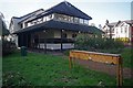
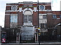
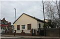
East Ham LNR Visitor Centre
This is the Visitor Centre of Image the box has various "nature table" items hidden inside that children are encouraged to identify by touch alone.
Image: © Glyn Baker
Taken: 23 Nov 2013
0.10 miles
9
St Mary Magdalene Churchyard, East Ham
St Mary Magdalene has possibly London's largest churchyard. St Mary Magdalene is one of the very few scarcely altered Norman churches to be found in the London area. The body of the church dates from about 1130, although Roman bricks are used in the construction alongside Norman pudding stone. The upper part of the tower dates from the 16th Century.
The churchyard is managed as a nature reserve by Newham Council and includes a visitor centre, built in 1981 and which was formally opened by the Queen in 1983. The visitor centre includes a classroom and a small museum display. The churchyard is known as East Ham Nature Reserve and was used as a model for the National Churchyard Conservation Campaign, which was launched here in 1991. The oldest part of the churchyard, around the church, is kept neat and tidy but much of the rest towards the south and east has been allowed to turn into woodland.
Image: © Marathon
Taken: 10 Mar 2015
0.11 miles
10

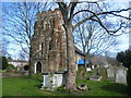
St Mary Magdalene Churchyard, East Ham
St Mary Magdalene has possibly London's largest churchyard. St Mary Magdalene is one of the very few scarcely altered Norman churches to be found in the London area. The body of the church dates from about 1130, although Roman bricks are used in the construction alongside Norman pudding stone. The upper part of the tower dates from the 16th Century. The churchyard is managed as a nature reserve by Newham Council and includes a visitor centre, built in 1981 and which was formally opened by the Queen in 1983. The visitor centre includes a classroom and a small museum display. The churchyard is known as East Ham Nature Reserve and was used as a model for the National Churchyard Conservation Campaign, which was launched here in 1991. The oldest part of the churchyard, around the church, is kept neat and tidy but much of the rest towards the south and east has been allowed to turn into woodland.
Image: © Marathon
Taken: 10 Mar 2015
0.11 miles