IMAGES TAKEN NEAR TO
Henniker Gardens, LONDON, E6 3JG
Introduction
This page details the photographs taken nearby to Henniker Gardens, E6 3JG by members of the Geograph project.
The Geograph project started in 2005 with the aim of publishing, organising and preserving representative images for every square kilometre of Great Britain, Ireland and the Isle of Man.

There are currently over 7.5m images from over14,400 individuals and you can help contribute to the project by visiting https://www.geograph.org.uk
Image Map (Loading...)


Getting Data...Please wait
Leaflet Map data © OpenStreetMap
Images are licensed for reuse under creativecommons.org/licenses/by-sa/2.0
Notes
- Clicking on the map will re-center to the selected point.
- The higher the marker number, the further away the image location is from the centre of the postcode.
Image Listing (8 Images Found)
Images are licensed for reuse under creativecommons.org/licenses/by-sa/2.0
Image
Details
Distance
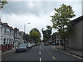
1

From the City's Cemetery to the Greenway (93)
Junction of Creighton Road and Central Park Road
Image: © Basher Eyre
Taken: 7 Jan 2012
0.16 miles
2

From the City's Cemetery to the Greenway (94)
Looking across Central Park Road towards Wilson Road
Image: © Basher Eyre
Taken: 7 Jan 2012
0.19 miles
3

From the City's Cemetery to the Greenway (95)
Scaffolding on a house in Wilson Road
Image: © Basher Eyre
Taken: 7 Jan 2012
0.19 miles
4

From the City's Cemetery to the Greenway (96)
Looking from Wilson Road into Benson Avenue
Image: © Basher Eyre
Taken: 7 Jan 2012
0.21 miles
5

From the City's Cemetery to the Greenway (97)
Approaching the junction of Wilson and Blenheim Roads
Image: © Basher Eyre
Taken: 7 Jan 2012
0.22 miles
6

From the City's Cemetery to the Greenway (98)
Looking from Wilson Road into Blenheim Road.
Image: © Basher Eyre
Taken: 7 Jan 2012
0.23 miles
7
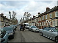
From the City's Cemetery to the Greenway (92)
Rag and bone cart in Creighton Avenue
Image: © Basher Eyre
Taken: 7 Jan 2012
0.24 miles