IMAGES TAKEN NEAR TO
Montpelier Gardens, LONDON, E6 3JF
Introduction
This page details the photographs taken nearby to Montpelier Gardens, E6 3JF by members of the Geograph project.
The Geograph project started in 2005 with the aim of publishing, organising and preserving representative images for every square kilometre of Great Britain, Ireland and the Isle of Man.

There are currently over 7.5m images from over14,400 individuals and you can help contribute to the project by visiting https://www.geograph.org.uk
Image Map
Images are licensed for reuse under creativecommons.org/licenses/by-sa/2.0
Notes
- Clicking on the map will re-center to the selected point.
- The higher the marker number, the further away the image location is from the centre of the postcode.
Image Listing (9 Images Found)
Images are licensed for reuse under creativecommons.org/licenses/by-sa/2.0
Image
Details
Distance
1

From the City's Cemetery to the Greenway (93)
Junction of Creighton Road and Central Park Road
Image: © Basher Eyre
Taken: 7 Jan 2012
0.22 miles
2
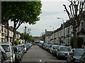
Thackeray Road, E6
One of the many straight roads built in a grid pattern in this area during the 19th Century.
Image: © Danny P Robinson
Taken: 20 May 2007
0.22 miles


5

Path Through Central Park, East Ham
Picture taken at Bartle Avenue entrance, looking towards Rancliffe Road entrance.
Image: © Danny P Robinson
Taken: 12 Feb 2008
0.24 miles

7
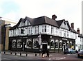
The Central, Barking Road E6
At the junction with Macaulay Road
Image: © Robin Sones
Taken: 27 Feb 2013
0.24 miles
8
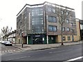
Boleyn Medical Centre, Barking Road E6
At the junction with Mafeking Avenue
Image: © Robin Sones
Taken: 27 Feb 2013
0.24 miles
