IMAGES TAKEN NEAR TO
Hatherley Gardens, LONDON, E6 3HG
Introduction
This page details the photographs taken nearby to Hatherley Gardens, E6 3HG by members of the Geograph project.
The Geograph project started in 2005 with the aim of publishing, organising and preserving representative images for every square kilometre of Great Britain, Ireland and the Isle of Man.

There are currently over 7.5m images from over14,400 individuals and you can help contribute to the project by visiting https://www.geograph.org.uk
Image Map
Images are licensed for reuse under creativecommons.org/licenses/by-sa/2.0
Notes
- Clicking on the map will re-center to the selected point.
- The higher the marker number, the further away the image location is from the centre of the postcode.
Image Listing (31 Images Found)
Images are licensed for reuse under creativecommons.org/licenses/by-sa/2.0
Image
Details
Distance
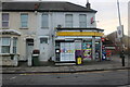
2
Boundary Road at the junction of New City Road
Image: © David Howard
Taken: 27 Apr 2014
0.20 miles
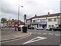
3
New City Road at the junction of Boundary Road
Image: © David Howard
Taken: 27 Apr 2014
0.20 miles
4

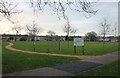
From the City's Cemetery to the Greenway (93)
Junction of Creighton Road and Central Park Road
Image: © Basher Eyre
Taken: 7 Jan 2012
0.20 miles
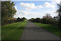
6
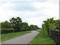
The Greenway, east of Boundary Lane
Looking east towards Beckton.
Image: © Stephen Craven
Taken: 15 May 2010
0.21 miles
9

From the City's Cemetery to the Greenway (95)
Scaffolding on a house in Wilson Road
Image: © Basher Eyre
Taken: 7 Jan 2012
0.22 miles
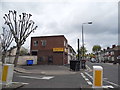
10

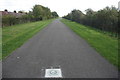
From the City's Cemetery to the Greenway (94)
Looking across Central Park Road towards Wilson Road
Image: © Basher Eyre
Taken: 7 Jan 2012
0.22 miles