IMAGES TAKEN NEAR TO
Harry Zeital Way, LONDON, E5 9RR
Introduction
This page details the photographs taken nearby to Harry Zeital Way, E5 9RR by members of the Geograph project.
The Geograph project started in 2005 with the aim of publishing, organising and preserving representative images for every square kilometre of Great Britain, Ireland and the Isle of Man.

There are currently over 7.5m images from over14,400 individuals and you can help contribute to the project by visiting https://www.geograph.org.uk
Image Map
Images are licensed for reuse under creativecommons.org/licenses/by-sa/2.0
Notes
- Clicking on the map will re-center to the selected point.
- The higher the marker number, the further away the image location is from the centre of the postcode.
Image Listing (123 Images Found)
Images are licensed for reuse under creativecommons.org/licenses/by-sa/2.0
Image
Details
Distance
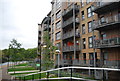
3
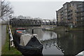
Flats beside the River Lee Navigation
A rainy day at Lea Bridge.
Image: © Trevor Harris
Taken: 5 Mar 2017
0.02 miles
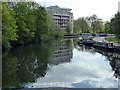
9
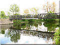
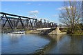
Bridge over the Lea
A footbridge over the River Lea at the northern end of North Mill Fields (on the west bank). It appears to have an unusually large span/depth ratio for a flat (non-arched) bridge.
Image: © Stephen Craven
Taken: 2 May 2009
0.03 miles
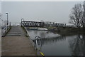
10
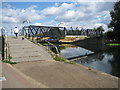
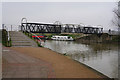
River Lee Navigation: King's Head Bridge
Judging by the cobbled ramp with its anti-slip ridges this bridge appears to have been built in order to switch the towing path from one side of this canalised river to the other. The reason for the name is unknown by the photographer and was taken from a map on a Lee Valley Park information board. Was it the name of a nearby pub?
Image: © Nigel Cox
Taken: 28 Jul 2010
0.03 miles