IMAGES TAKEN NEAR TO
Harrington Hill, LONDON, E5 9HF
Introduction
This page details the photographs taken nearby to Harrington Hill, E5 9HF by members of the Geograph project.
The Geograph project started in 2005 with the aim of publishing, organising and preserving representative images for every square kilometre of Great Britain, Ireland and the Isle of Man.

There are currently over 7.5m images from over14,400 individuals and you can help contribute to the project by visiting https://www.geograph.org.uk
Image Map
Images are licensed for reuse under creativecommons.org/licenses/by-sa/2.0
Notes
- Clicking on the map will re-center to the selected point.
- The higher the marker number, the further away the image location is from the centre of the postcode.
Image Listing (123 Images Found)
Images are licensed for reuse under creativecommons.org/licenses/by-sa/2.0
Image
Details
Distance
2
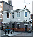
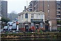
Clapton : "The Anchor and Hope" public house
Image: © Jim Osley
Taken: 4 Jan 2019
0.01 miles
4
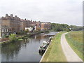
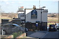
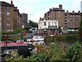
River Lea from train
A view of the River Lea through Walthamstow Marshes. The right hand bank is Walthamstow and the left is Clapton. The white building just left of centre is the "Anchor and Hope" pub at the bottom of Harrington Hill Clapton.
Image: © Richard Dunn
Taken: 18 Sep 2009
0.01 miles
7
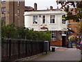
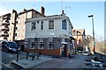
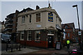
The Anchor and Hope Pub
The anchor and Hope pub is situated at the corner of Harrington Hill Clapton and the West bank of the River Lea.
Image: © Richard Dunn
Taken: 21 Sep 2009
0.02 miles