IMAGES TAKEN NEAR TO
Jessam Avenue, LONDON, E5 9DF
Introduction
This page details the photographs taken nearby to Jessam Avenue, E5 9DF by members of the Geograph project.
The Geograph project started in 2005 with the aim of publishing, organising and preserving representative images for every square kilometre of Great Britain, Ireland and the Isle of Man.

There are currently over 7.5m images from over14,400 individuals and you can help contribute to the project by visiting https://www.geograph.org.uk
Image Map
Images are licensed for reuse under creativecommons.org/licenses/by-sa/2.0
Notes
- Clicking on the map will re-center to the selected point.
- The higher the marker number, the further away the image location is from the centre of the postcode.
Image Listing (142 Images Found)
Images are licensed for reuse under creativecommons.org/licenses/by-sa/2.0
Image
Details
Distance
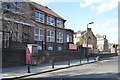
1
Hawkwood Mount, E5
These substantial houses back onto Springfield Park.
Image: © Danny P Robinson
Taken: 1 Apr 2007
0.05 miles
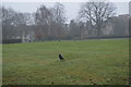
2
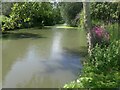
The pond in Springfield Park
Springfield Park was formed in 1905 from the grounds of three private houses, of which one, the White Lodge (or ‘Springfield House’), dating from the 19th century, survives in the south-west corner of the park. Springfield Park provides fine views across the Lea Valley and Walthamstow Marshes. The flower is purple loosestrife.
Image: © Marathon
Taken: 24 Aug 2021
0.09 miles
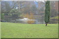
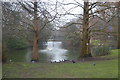
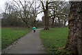
6
Springfield Park
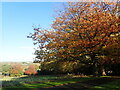
Springfield Park was formed in 1905 from the grounds of three private houses, of which one, the White Lodge (or ‘Springfield House’), dating from the 19th century, survives in the south-west corner of the park. Springfield Park provides fine views across the Lea Valley and Walthamstow Marshes.
Image: © Marathon
Taken: 1 Nov 2021
0.12 miles
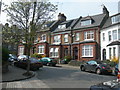
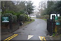
7
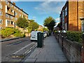
Jessam Avenue, Clapton
None of the roads east of Upper Clapton Road go anywhere due to the River Lea.
Image: © David Howard
Taken: 3 Oct 2021
0.12 miles