IMAGES TAKEN NEAR TO
Monteagle Way, LONDON, E5 8PQ
Introduction
This page details the photographs taken nearby to Monteagle Way, E5 8PQ by members of the Geograph project.
The Geograph project started in 2005 with the aim of publishing, organising and preserving representative images for every square kilometre of Great Britain, Ireland and the Isle of Man.

There are currently over 7.5m images from over14,400 individuals and you can help contribute to the project by visiting https://www.geograph.org.uk
Image Map
Images are licensed for reuse under creativecommons.org/licenses/by-sa/2.0
Notes
- Clicking on the map will re-center to the selected point.
- The higher the marker number, the further away the image location is from the centre of the postcode.
Image Listing (49 Images Found)
Images are licensed for reuse under creativecommons.org/licenses/by-sa/2.0
Image
Details
Distance
1
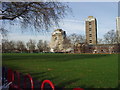
A way through the estate, 2011
The block at the immediate left has since been demolished.
Image: © Robin Webster
Taken: 5 Feb 2011
0.08 miles
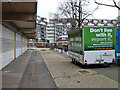
2
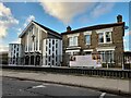
Development site by Hackney Downs
See Image for the final view of what was there.
Image: © Hugh Venables
Taken: 8 Mar 2015
0.09 miles
3
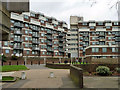
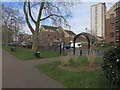
Nightingale Estate, E5
An estate largely of blocks of flats similar to these.
Image: © Robin Webster
Taken: 5 Feb 2011
0.09 miles
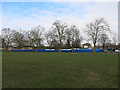
5
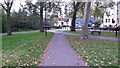
The Final Blowdown
The wrongs of the past righted.
Image: © JonnyHolt
Taken: 30 Jan 2004
0.13 miles
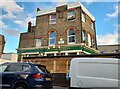
10

Walsingham Road at the junction of Rendlesham Road
Yes, there is definitely a Norfolk theme here. The school on the corner is embarrassed to show its name but is called Nightingale Primary School.
Image: © David Howard
Taken: 3 Oct 2021
0.17 miles