IMAGES TAKEN NEAR TO
Clifden Mews, LONDON, E5 0LR
Introduction
This page details the photographs taken nearby to Clifden Mews, E5 0LR by members of the Geograph project.
The Geograph project started in 2005 with the aim of publishing, organising and preserving representative images for every square kilometre of Great Britain, Ireland and the Isle of Man.

There are currently over 7.5m images from over14,400 individuals and you can help contribute to the project by visiting https://www.geograph.org.uk
Image Map
Images are licensed for reuse under creativecommons.org/licenses/by-sa/2.0
Notes
- Clicking on the map will re-center to the selected point.
- The higher the marker number, the further away the image location is from the centre of the postcode.
Image Listing (56 Images Found)
Images are licensed for reuse under creativecommons.org/licenses/by-sa/2.0
Image
Details
Distance
2
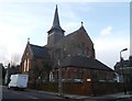
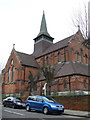
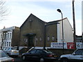
Church of St Paul, Lower Clapton
This Grade II listed church is on the junction of Glyn Road and Chelmer Road (on the left).
After it became redundant for Anglican worship in the latter part of the 20th Century, the church has became part of the Celestial Church of Christ. It was then taken over by the Seventh Day Adventists in 2006.
Now known as Clapton Seventh Day Adventists Church.
See http://www.britishlistedbuildings.co.uk/en-423663-former-church-of-st-paul-greater-london- for more details about the church building.
Image: © David Anstiss
Taken: 27 Jan 2013
0.04 miles
4
Chats Palace
An arts and community centre and theatre on Brooksby's Walk, Homerton.
Image: © Trevor Harris
Taken: 8 Jul 2017
0.11 miles
5
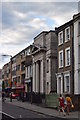
171 Glenarm Road, Lower Clapton
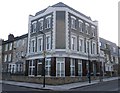
This imposing house on the junction of Glenarm Road (on the right) and Glyn Road, was once The George public house (in 2005!). Now converted into flats.
See http://pubshistory.com/LondonPubs/Hackney/George.shtml for a picture of the former pub.
Image: © David Anstiss
Taken: 27 Jan 2013
0.13 miles
6
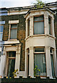
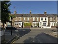
Rushmore Road, Hackney, London E5
House is typical of the kind of properties which were built in this area.
Image: © Christine Matthews
Taken: Unknown
0.15 miles
8
St Judes Roman Catholic Church, Hackney
On Blurton Road.
Image: © David Anstiss
Taken: 27 Jan 2013
0.17 miles
9
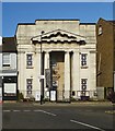
Chat's Palace, Homerton
Chat's Palace is an arts and community centre housed in a former public library built 1912-1913 to the designs of architect Edwin Cooper. A Grade II listed building, described at this http://list.english-heritage.org.uk/resultsingle.aspx?uid=1235655.
Image: © Jim Osley
Taken: 18 Jul 2014
0.17 miles
10
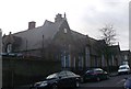
Daubeney Infants' School, Hackney
Grade II listed Infants School on Colne Road
See http://www.britishlistedbuildings.co.uk/en-423941-daubeny-infants-school-greater-london-au about the listed school building.
Image: © David Anstiss
Taken: 27 Jan 2013
0.18 miles