IMAGES TAKEN NEAR TO
Daubeney Road, LONDON, E5 0EN
Introduction
This page details the photographs taken nearby to Daubeney Road, E5 0EN by members of the Geograph project.
The Geograph project started in 2005 with the aim of publishing, organising and preserving representative images for every square kilometre of Great Britain, Ireland and the Isle of Man.

There are currently over 7.5m images from over14,400 individuals and you can help contribute to the project by visiting https://www.geograph.org.uk
Image Map
Images are licensed for reuse under creativecommons.org/licenses/by-sa/2.0
Notes
- Clicking on the map will re-center to the selected point.
- The higher the marker number, the further away the image location is from the centre of the postcode.
Image Listing (54 Images Found)
Images are licensed for reuse under creativecommons.org/licenses/by-sa/2.0
Image
Details
Distance
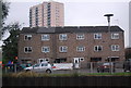
1
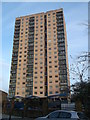
Landmark Heights, Clapton Park
This large block of housing is on Daubeney Road. It was once called Sudbury Court. During the 1990s regeneration of the Clapton Park area, it was refurbished and renamed. It is part of the Clapton Park Estate.
Image: © David Anstiss
Taken: 27 Jan 2013
0.01 miles
3
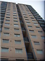
Looking up at Landmark Heights
Landmark Heights is a 20-odd storey block of flats close to the edge of Hackney Marshes. As its name suggests, it forms something of a landmark, and I was there for Christmas.
Image: © Ben Harris
Taken: 25 Dec 2010
0.01 miles
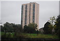
4
Daubeney Road, London E5
Both the low-rise flats and Landmark Heights (the tower block) are situated in Daubeney Road. The footbridge links the end of the road with Hackney Marsh on the opposite side of the River Lee Navigation.
Image: © David Kemp
Taken: 22 Nov 2016
0.08 miles
6
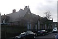
Daubeney Infants' School, Hackney
Grade II listed Infants School on Colne Road
See http://www.britishlistedbuildings.co.uk/en-423941-daubeny-infants-school-greater-london-au about the listed school building.
Image: © David Anstiss
Taken: 27 Jan 2013
0.10 miles
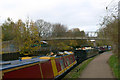
7
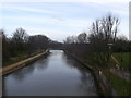
Lea Navigation (Hackney Cut)
As seen from Image
The tow path (part of the Capital Ring) can be seen on the left.
Image: © David Anstiss
Taken: 27 Jan 2013
0.11 miles
8
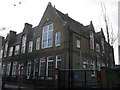
Daubeney Junior School, Lower Clapton (2)
Grade II listed Junior School on Daubeney Road
See http://www.britishlistedbuildings.co.uk/en-423939-daubeny-junior-school-greater-london-aut about the listed school building.
Image: © David Anstiss
Taken: 27 Jan 2013
0.11 miles
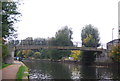
10
Hackney Marsh footbridge across River Lee Navigation
Sometimes known as the Daubeney Road footbridge.
Image: © David Kemp
Taken: 22 Nov 2016
0.11 miles