IMAGES TAKEN NEAR TO
Newbury Road, LONDON, E4 9JH
Introduction
This page details the photographs taken nearby to Newbury Road, E4 9JH by members of the Geograph project.
The Geograph project started in 2005 with the aim of publishing, organising and preserving representative images for every square kilometre of Great Britain, Ireland and the Isle of Man.

There are currently over 7.5m images from over14,400 individuals and you can help contribute to the project by visiting https://www.geograph.org.uk
Image Map (Loading...)


Getting Data...Please wait
Leaflet Map data © OpenStreetMap
Images are licensed for reuse under creativecommons.org/licenses/by-sa/2.0
Notes
- Clicking on the map will re-center to the selected point.
- The higher the marker number, the further away the image location is from the centre of the postcode.
Image Listing (28 Images Found)
Images are licensed for reuse under creativecommons.org/licenses/by-sa/2.0
Image
Details
Distance
1
Level Crossing, Highams Park
In the middle of the top half of the grid square. Highams Park station is just off the picture to the right.
Image: © Claire Ward
Taken: 15 Jun 2005
0.07 miles
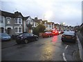
3
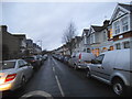
Beech Hall Road at the corner of Studley Avenue
Image: © David Howard
Taken: 8 Dec 2016
0.10 miles
5
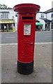
Edward VII postbox on Winchester Road, Highams Park
Postbox No. E4 9.
See Image] for context.
Image: © JThomas
Taken: 6 Jul 2019
0.15 miles
6
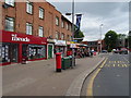
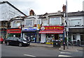
Shops on Winchester Road, Highams Park
Showing position of Postbox No. E4 9.
See Image] for postbox.
Image: © JThomas
Taken: 6 Jul 2019
0.16 miles
8
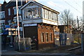
Former signal box by level crossing at Highams Park
Now trading as a creperie!
Image: © David Martin
Taken: 18 Feb 2017
0.17 miles
10
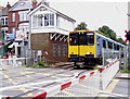
Highams Park Level Crossing & Signal Box
The level crossing at Highams Park joins Hale End Road to the East with Larkshall Road and Winchester Road to the West. The signal box is now out of use as the crossing is controlled by CCTV from Liverpool Street some 7 miles away. The signal box was restored in 2002 and is leased to the Highams Park Signal Box association. See photo Image]
Image: © Richard Dunn
Taken: 25 Aug 2008
0.17 miles