IMAGES TAKEN NEAR TO
Underwood Road, LONDON, E4 9EE
Introduction
This page details the photographs taken nearby to Underwood Road, E4 9EE by members of the Geograph project.
The Geograph project started in 2005 with the aim of publishing, organising and preserving representative images for every square kilometre of Great Britain, Ireland and the Isle of Man.

There are currently over 7.5m images from over14,400 individuals and you can help contribute to the project by visiting https://www.geograph.org.uk
Image Map (Loading...)


Getting Data...Please wait
Leaflet Map data © OpenStreetMap
Images are licensed for reuse under creativecommons.org/licenses/by-sa/2.0
Notes
- Clicking on the map will re-center to the selected point.
- The higher the marker number, the further away the image location is from the centre of the postcode.
Image Listing (29 Images Found)
Images are licensed for reuse under creativecommons.org/licenses/by-sa/2.0
Image
Details
Distance
1
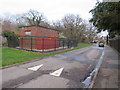
Inks Green, near Chingford
Inks Green near Chingford in the outer suburbs of north east London.
The small brick building on the opposite side of the road is an electricity substation. In the foreground, the road has a speed hump.
Image: © Malc McDonald
Taken: 7 Mar 2020
0.06 miles
2
![Trees along Inks Green, Chingford Hatch [1]](https://s1.geograph.org.uk/geophotos/04/79/35/4793545_4b3db030_120x120.jpg)
Trees along Inks Green, Chingford Hatch [1]
The southern perimeter of Larks Wood [Larkswood Park].
Image: © Christine Johnstone
Taken: 11 Jan 2016
0.06 miles
3
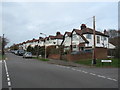
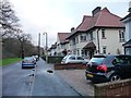
Underwood Road, near Chingford
Underwood Road is a residential road near Chingford in the outer suburbs of north east London.
Image: © Malc McDonald
Taken: 7 Mar 2020
0.07 miles
4
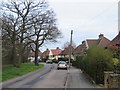
Inks Green, near Chingford
Inks Green is a minor residential road near Chingford, in the outer suburbs of north east London. The road is on the edge of woodland.
Image: © Malc McDonald
Taken: 7 Mar 2020
0.07 miles
5
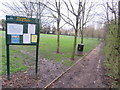
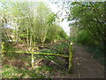
Ainslie Wood, near Chingford
A path leading into Ainslie Wood, near Chingford in the north east London suburbs.
The wood itself is out of sight in this image.
Image: © Malc McDonald
Taken: 7 Mar 2020
0.08 miles
6
![Trees along Inks Green, Chingford Hatch [2]](https://s3.geograph.org.uk/geophotos/04/79/35/4793547_db50dd89_120x120.jpg)
Trees along Inks Green, Chingford Hatch [2]
The southern edge of Larks Wood [Larkswood Park].
Image: © Christine Johnstone
Taken: 11 Jan 2016
0.09 miles
7
Semi-detached houses, Inks Green, Chingford Hatch
On the south side of the road, facing Larks Wood.
Image: © Christine Johnstone
Taken: 11 Jan 2016
0.10 miles
8
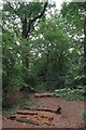
Pond in Ainslie Wood
Ainslie Wood was once known as Endsleigh Wood. It is an L-shaped piece of ancient woodland and became separated from the nearby Larks Wood early in the 20th century. It is now surrounded by houses and a recreation ground. The wood is locally famed for its show of bluebells, to such a degree that many people actually call it Bluebell Wood. This small pond was actually created in the 1980s. Ainslie Wood is owned by Waltham Forest Council and managed by the Council and the Friends of Ainslie and Larks Woods.
Image: © Marathon
Taken: 5 Apr 2017
0.10 miles
9
Ainslie Wood
This five acre ancient woodland was once part of Epping Forest, it is now managed by Waltham Forest Council as a nature reserve. For more information see http://www.wildessex.net/sites/Ainslie%20Wood.htm
Image: © Glyn Baker
Taken: 4 Aug 2016
0.11 miles
10
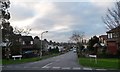
Palace View Road, Chingford
Dropping westwards from Underwood Road. The name might refer to Alexandra Palace, which is on a ridge 8.6 kms away, in the direction of the road.
Image: © Christine Johnstone
Taken: 11 Jan 2016
0.13 miles