IMAGES TAKEN NEAR TO
Westward Road, LONDON, E4 8TP
Introduction
This page details the photographs taken nearby to Westward Road, E4 8TP by members of the Geograph project.
The Geograph project started in 2005 with the aim of publishing, organising and preserving representative images for every square kilometre of Great Britain, Ireland and the Isle of Man.

There are currently over 7.5m images from over14,400 individuals and you can help contribute to the project by visiting https://www.geograph.org.uk
Image Map (Loading...)


Getting Data...Please wait
Leaflet Map data © OpenStreetMap
Images are licensed for reuse under creativecommons.org/licenses/by-sa/2.0
Notes
- Clicking on the map will re-center to the selected point.
- The higher the marker number, the further away the image location is from the centre of the postcode.
Image Listing (19 Images Found)
Images are licensed for reuse under creativecommons.org/licenses/by-sa/2.0
Image
Details
Distance
1
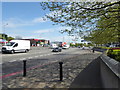
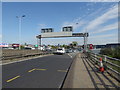
The North Circular Road near the Lea Valley
This view of the North Circular Road is just before it passes over a flyover above the River Lea and Lee Navigation to the left, out of the picture.
Image: © Marathon
Taken: 12 Apr 2017
0.02 miles
2
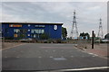
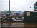
Safestore on the North Circular slip road, Highams Park
Image: © David Howard
Taken: 13 Jul 2019
0.07 miles
3
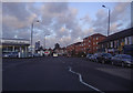
Sinclair Road at the North Circular slip road
Image: © David Howard
Taken: 13 Jul 2019
0.07 miles
5
Cork Tree Retail Park on the North Circular Road, Highams Park
Image: © David Howard
Taken: 20 Jan 2018
0.11 miles
6

Business Park South Chingford
The warehouses are situated at a lower level to the
viaducts carrying the traffic. {which was stationary and allowed me to get the camera working}
Image: © Jack Hill
Taken: 9 Aug 2005
0.12 miles
7
The North Circular Road
The North Circular Road itself is on the other side of the barrier as it passes over a flyover above the River Lea and Lee Navigation. This is a slip road down to a roundabout giving access to industrial areas as well as the London EcoPark - see https://en.wikipedia.org/wiki/London_EcoPark
Image: © Marathon
Taken: 12 Apr 2017
0.16 miles
8
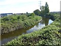
River Lea seen from the North Circular Road
The original River Lea flowed 70 miles from Leagrove Marsh near Luton to the River Thames at Bow Creek. The River Lee Act of 1766 provided for the construction of 15 new cuts to straighten the course of the river by eliminating loops which made it difficult to navigate. The River Lee Navigation just west of here is one of those cuts and hence it is a navigation rather than a river.
This though is the River Lea, seen here from the slip road of the North Circular Road at http://www.geograph.org.uk/photo/5347537 Unlike the Lee Navigation it is not accessible here. Historically the river is spelled Lea while the navigation is Lee.
Image: © Marathon
Taken: 12 Apr 2017
0.16 miles
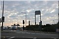
9

Sunset on the north circular
A406 junction with the A1009
Image: © Effie Jessop
Taken: 29 Jun 2009
0.17 miles
10
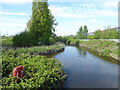
River Lea seen from Harbet Road
The original River Lea flowed 70 miles from Leagrove Marsh near Luton to the River Thames at Bow Creek. The River Lee Act of 1766 provided for the construction of 15 new cuts to straighten the course of the river by eliminating loops which made it difficult to navigate. The River Lee Navigation just west of here is one of those cuts and hence it is a navigation rather than a river.
This though is the River Lea, seen here from Harbet Road. Unlike the Lee Navigation it is not accessible here. Historically the river is spelled Lea while the navigation is Lee.
Image: © Marathon
Taken: 12 Apr 2017
0.19 miles