IMAGES TAKEN NEAR TO
Southend Road, LONDON, E4 8TA
Introduction
This page details the photographs taken nearby to Southend Road, E4 8TA by members of the Geograph project.
The Geograph project started in 2005 with the aim of publishing, organising and preserving representative images for every square kilometre of Great Britain, Ireland and the Isle of Man.

There are currently over 7.5m images from over14,400 individuals and you can help contribute to the project by visiting https://www.geograph.org.uk
Image Map (Loading...)


Getting Data...Please wait
Leaflet Map data © OpenStreetMap
Images are licensed for reuse under creativecommons.org/licenses/by-sa/2.0
Notes
- Clicking on the map will re-center to the selected point.
- The higher the marker number, the further away the image location is from the centre of the postcode.
Image Listing (3 Images Found)
Images are licensed for reuse under creativecommons.org/licenses/by-sa/2.0
Image
Details
Distance
1

Field in rural Tottenham
Taken from Folly Lane Community Woodland, looking across Folly Lane towards the embankment of Banbury Reservoir. There are usually horses grazing in the field, but unfortunately not today. The pink flowers in the foreground are wild sweet peas.
Image: © Antony Dixon
Taken: 19 Jun 2014
0.21 miles
2
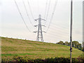
Pylon and reservoir bank
There are a great many of each in the Lee Valley. The bank here here belongs to Banbury Reservoir.
Image: © Robin Webster
Taken: 20 Oct 2012
0.23 miles
3
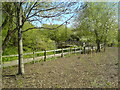
Bridge over the River Ching
The bridge over the River Ching is on a footpath from Sainsbury's Car park to a small copse opposite Walthamstow Stadium in Chingford Road on the borders of Chingford and Walthamstow.
Image: © Richard Dunn
Taken: 22 Apr 2010
0.25 miles