IMAGES TAKEN NEAR TO
Hollywood Road, LONDON, E4 8JE
Introduction
This page details the photographs taken nearby to Hollywood Road, E4 8JE by members of the Geograph project.
The Geograph project started in 2005 with the aim of publishing, organising and preserving representative images for every square kilometre of Great Britain, Ireland and the Isle of Man.

There are currently over 7.5m images from over14,400 individuals and you can help contribute to the project by visiting https://www.geograph.org.uk
Image Map (Loading...)


Getting Data...Please wait
Leaflet Map data © OpenStreetMap
Images are licensed for reuse under creativecommons.org/licenses/by-sa/2.0
Notes
- Clicking on the map will re-center to the selected point.
- The higher the marker number, the further away the image location is from the centre of the postcode.
Image Listing (16 Images Found)
Images are licensed for reuse under creativecommons.org/licenses/by-sa/2.0
Image
Details
Distance
2
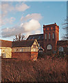
Chingford Mill Pumping Station and Turbine House
Built between 1891 and 1895. Information extracted from: The Buildings of England. London 5: East. New Haven, London : Yale University Press, 2005, p. 717. More at this http://walthamforest-consult.limehouse.co.uk/portal/pp/ldds/ssa/ssapo/ssapo?pointId=s1358161709286. The church-like pumping station and turbine house are both Grade II listed buildings, described at this https://historicengland.org.uk/listing/the-list/list-entry/1250896 and this https://historicengland.org.uk/listing/the-list/list-entry/1065574.
Image: © Jim Osley
Taken: 3 Feb 2016
0.13 miles
3
Chingford Mill Pumping Station and Turbine House
Built between 1891 and 1895. Information extracted from: The Buildings of England. London 5: East. New Haven, London : Yale University Press, 2005, p. 717. More at this http://walthamforest-consult.limehouse.co.uk/portal/pp/ldds/ssa/ssapo/ssapo?pointId=s1358161709286. The church-like pumping station and turbine house are both Grade II listed buildings, described at this https://historicengland.org.uk/listing/the-list/list-entry/1250896 and this https://historicengland.org.uk/listing/the-list/list-entry/1065574.
Image: © Jim Osley
Taken: 29 May 2020
0.13 miles
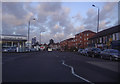
5
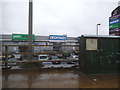
Cork Tree Retail Park on the North Circular Road, Highams Park
Image: © David Howard
Taken: 20 Jan 2018
0.16 miles
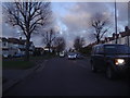
6
Sinclair Road at the North Circular slip road
Image: © David Howard
Taken: 13 Jul 2019
0.17 miles
7
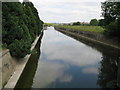
River Lee Diversion near Chingford
The River Lee (or Lea) used to slowly meander through this area, but in order to better control the flow of water, and to provide space for the various reservoirs down this part of the Lee valley, this long broad concrete conduit was built, probably between the two World Wars. This is the view looking north from the Lower Hall Lane bridge. The boundary between the London Boroughs of Enfield to the left, and Waltham Forest to the right, passes down the centre of the river.
Image: © Nigel Cox
Taken: 10 Jun 2008
0.17 miles
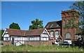
8
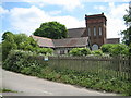
Chingford Mill Pumping Station (disused)
Erected in 1895 by the ELWWCo (East London Water Works Company?) the large building is Grade II listed and is the subject of a planning application to convert it into residential use. This was originally the site of Chingford Mill which produced flour.
Image: © Nigel Cox
Taken: 10 Jun 2008
0.17 miles
9
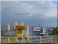
Business Park South Chingford
The warehouses are situated at a lower level to the
viaducts carrying the traffic. {which was stationary and allowed me to get the camera working}
Image: © Jack Hill
Taken: 9 Aug 2005
0.19 miles
10
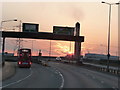
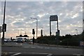
Sunset on the north circular
A406 junction with the A1009
Image: © Effie Jessop
Taken: 29 Jun 2009
0.20 miles