IMAGES TAKEN NEAR TO
Waverley Avenue, LONDON, E4 8HT
Introduction
This page details the photographs taken nearby to Waverley Avenue, E4 8HT by members of the Geograph project.
The Geograph project started in 2005 with the aim of publishing, organising and preserving representative images for every square kilometre of Great Britain, Ireland and the Isle of Man.

There are currently over 7.5m images from over14,400 individuals and you can help contribute to the project by visiting https://www.geograph.org.uk
Image Map (Loading...)


Getting Data...Please wait
Leaflet Map data © OpenStreetMap
Images are licensed for reuse under creativecommons.org/licenses/by-sa/2.0
Notes
- Clicking on the map will re-center to the selected point.
- The higher the marker number, the further away the image location is from the centre of the postcode.
Image Listing (7 Images Found)
Images are licensed for reuse under creativecommons.org/licenses/by-sa/2.0
Image
Details
Distance
4
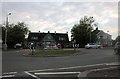
The Old Hall Tavern, Highams Park
A recent visit https://www.geograph.org.uk/photo/5691488
Image: © David Howard
Taken: 13 Jul 2019
0.10 miles
7
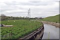
Channel to the South of William Girling Reservoir
Sheep are not the kind of creatures I would instantly associate with Edmonton!
Image: © Glyn Baker
Taken: 28 Apr 2016
0.24 miles