IMAGES TAKEN NEAR TO
Eatons Mead, LONDON, E4 8AN
Introduction
This page details the photographs taken nearby to Eatons Mead, E4 8AN by members of the Geograph project.
The Geograph project started in 2005 with the aim of publishing, organising and preserving representative images for every square kilometre of Great Britain, Ireland and the Isle of Man.

There are currently over 7.5m images from over14,400 individuals and you can help contribute to the project by visiting https://www.geograph.org.uk
Image Map
Images are licensed for reuse under creativecommons.org/licenses/by-sa/2.0
Notes
- Clicking on the map will re-center to the selected point.
- The higher the marker number, the further away the image location is from the centre of the postcode.
Image Listing (8 Images Found)
Images are licensed for reuse under creativecommons.org/licenses/by-sa/2.0
Image
Details
Distance
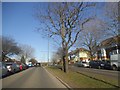
1
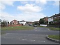
Eatons Mead from Waltham Way, Chingford
Image: © David Howard
Taken: 9 Apr 2014
0.08 miles
3
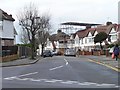
House with a temporary roof, Chingford
On the north side of Lambourne Gardens.
Image: © Christine Johnstone
Taken: 11 Jan 2016
0.16 miles
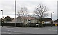
4
Houses in blocks of four, Old Church Road, Chingford
On the west side of the A112.
Image: © Christine Johnstone
Taken: 11 Jan 2016
0.17 miles
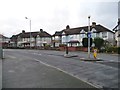
6
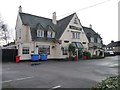
The Greene Man pub, Chingford
On the east side of Old Church Road.
Image: © Christine Johnstone
Taken: 11 Jan 2016
0.22 miles
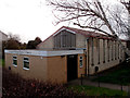
8
Chingford Mount Baptist Church
At the junction of Leadale Road and Old Church Road. Also functions as a polling station.
Image: © Christine Johnstone
Taken: 11 Jan 2016
0.24 miles