IMAGES TAKEN NEAR TO
Valley Side Parade, LONDON, E4 8AJ
Introduction
This page details the photographs taken nearby to Valley Side Parade, E4 8AJ by members of the Geograph project.
The Geograph project started in 2005 with the aim of publishing, organising and preserving representative images for every square kilometre of Great Britain, Ireland and the Isle of Man.

There are currently over 7.5m images from over14,400 individuals and you can help contribute to the project by visiting https://www.geograph.org.uk
Image Map (Loading...)


Getting Data...Please wait
Leaflet Map data © OpenStreetMap
Images are licensed for reuse under creativecommons.org/licenses/by-sa/2.0
Notes
- Clicking on the map will re-center to the selected point.
- The higher the marker number, the further away the image location is from the centre of the postcode.
Image Listing (7 Images Found)
Images are licensed for reuse under creativecommons.org/licenses/by-sa/2.0
Image
Details
Distance
1
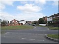
Eatons Mead from Waltham Way, Chingford
Image: © David Howard
Taken: 9 Apr 2014
0.14 miles
3
House with a temporary roof, Chingford
On the north side of Lambourne Gardens.
Image: © Christine Johnstone
Taken: 11 Jan 2016
0.17 miles
4
Houses in blocks of four, Old Church Road, Chingford
On the west side of the A112.
Image: © Christine Johnstone
Taken: 11 Jan 2016
0.20 miles
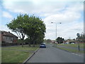
5
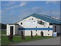
Chingford Rugby Club
The football ground is sandwiched between the bypass and the river Lee. A golf range is being redeveloped alongside the ground.
Image: © Jack Hill
Taken: 9 Aug 2005
0.22 miles
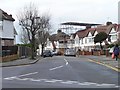
6
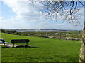
The view from Mansfield Park
The main feature of Mansfield Park is the impressive vista to William Girling Reservoir straight ahead and (just glimpsed on the extreme right) King George's Reservoir. For King George's Reservoir, the excavation and building of the surrounding embankment of the reservoir, nearly five miles in length, was carried out almost entirely by a manual labour force of 1,000 navvies, and the surplus excavated clay was spread over part of Hackney Marsh. In 1913 King George V and Queen Mary named the reservoir and pressed the buttons allowing water from the River Lea to start flowing into the storage bowl.
Work on the William Girling Reservoir did not start until 1935. During the First World War the site had been used by the Royal Naval Air Service and construction was held up by the Second World War. The surplus of clay was spread over the ground to the south of the new reservoir between the River Lea Diversion and the River Lea Navigation, thus raising the level of the ground and obliterating what remained of the River Lea in Chingford. The reservoir was finally opened in 1951 by the Chairman of the Metropolitan Water Board, Mr William H. Girling.
Image: © Marathon
Taken: 5 Apr 2017
0.25 miles
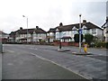
7
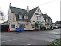
The Greene Man pub, Chingford
On the east side of Old Church Road.
Image: © Christine Johnstone
Taken: 11 Jan 2016
0.25 miles