IMAGES TAKEN NEAR TO
Chelwood Close, LONDON, E4 7UW
Introduction
This page details the photographs taken nearby to Chelwood Close, E4 7UW by members of the Geograph project.
The Geograph project started in 2005 with the aim of publishing, organising and preserving representative images for every square kilometre of Great Britain, Ireland and the Isle of Man.

There are currently over 7.5m images from over14,400 individuals and you can help contribute to the project by visiting https://www.geograph.org.uk
Image Map
Images are licensed for reuse under creativecommons.org/licenses/by-sa/2.0
Notes
- Clicking on the map will re-center to the selected point.
- The higher the marker number, the further away the image location is from the centre of the postcode.
Image Listing (14 Images Found)
Images are licensed for reuse under creativecommons.org/licenses/by-sa/2.0
Image
Details
Distance
1
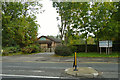
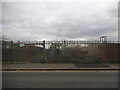
Sewardstone Evangelical Church
Sunday service 11 a.m.
Image: © Robin Webster
Taken: 20 Oct 2012
0.04 miles
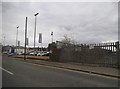
2
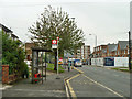
Amesbury Drive southbound bus stop
On Sewardstone Road, served by routes 215 and 505. Route 505 is not a London bus route, it provides an hourly service from Harlow to Chingford.
Image: © Robin Webster
Taken: 20 Oct 2012
0.09 miles
3
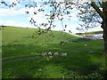
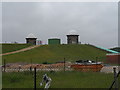
Sheep grazing the slope of King George's Reservoir
The excavation and building of the surrounding embankment of King George's Reservoir nearly five miles in length, was carried out almost entirely by a manual labour force of 1,000 navvies, and the surplus excavated clay was spread over part of Hackney Marsh. In 1913 King George Vth and Queen Mary named the reservoir and pressed the buttons allowing water from the River Lea to start flowing into the storage bowl.
This view is from Lea Valley Road. On the other side of the road is William Girling Reservoir - see http://www.geograph.org.uk/photo/5356682
Image: © Marathon
Taken: 19 Apr 2017
0.14 miles
7
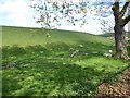
Sheep grazing the slope of King George's Reservoir
The excavation and building of the surrounding embankment of King George's Reservoir nearly five miles in length, was carried out almost entirely by a manual labour force of 1,000 navvies, and the surplus excavated clay was spread over part of Hackney Marsh. In 1913 King George Vth and Queen Mary named the reservoir and pressed the buttons allowing water from the River Lea to start flowing into the storage bowl.
This view is from Lea Valley Road. On the other side of the road is William Girling Reservoir - see http://www.geograph.org.uk/photo/5356682
Image: © Marathon
Taken: 19 Apr 2017
0.17 miles
8
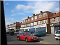
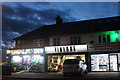
Shopping Parade at Chingford Green crossroads
The Mansard roof construction is rather unusual above shops but obviously the developer thought it would be worthwhile.
Image: © Jack Hill
Taken: 9 Aug 2005
0.18 miles
10

The Former Fountain Public House Chingford
Located at 51 Sewardstone Road, Chingford, E4
Image: © Phil Gaskin
Taken: 15 Apr 2011
0.21 miles