IMAGES TAKEN NEAR TO
Daws Hill, LONDON, E4 7QU
Introduction
This page details the photographs taken nearby to Daws Hill, E4 7QU by members of the Geograph project.
The Geograph project started in 2005 with the aim of publishing, organising and preserving representative images for every square kilometre of Great Britain, Ireland and the Isle of Man.

There are currently over 7.5m images from over14,400 individuals and you can help contribute to the project by visiting https://www.geograph.org.uk
Image Map (Loading...)


Getting Data...Please wait
Leaflet Map data © OpenStreetMap
Images are licensed for reuse under creativecommons.org/licenses/by-sa/2.0
Notes
- Clicking on the map will re-center to the selected point.
- The higher the marker number, the further away the image location is from the centre of the postcode.
Image Listing (14 Images Found)
Images are licensed for reuse under creativecommons.org/licenses/by-sa/2.0
Image
Details
Distance
3
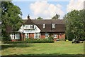
House in Gilwell Park
Gilwell Park belongs to the Scout Association who use it as a training and activity centre.
Image: © Des Blenkinsopp
Taken: 24 Jul 2014
0.06 miles
4
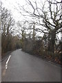
Field entrance on Daws Hill, Sewardstone
Image: © David Howard
Taken: 20 Jan 2018
0.06 miles
5
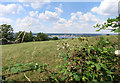
Blackberries on Barn Hill
Looking down onto King George's Reservoir from the London Loop path.
Image: © Des Blenkinsopp
Taken: 24 Jul 2014
0.08 miles
6
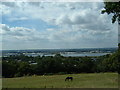
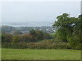
King George V Reservoir
The view from Barn Hill looking West. King George V Reservoir was completed in 1913 and supplies over a quarter of London's water. The right of the photograph shows the northerly edge of the reservoirs of the Lea (or Lee) valley which continue south as far as the eye can see.
Image: © Claire Ward
Taken: 4 Aug 2005
0.08 miles
7
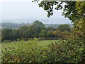
View from the London LOOP
The London LOOP heads uphill from Daws Hill to pass near the top of Barn Hill. On the way up this provides fine views across the Lea Valley. In this photograph on a misty early autumn day after a foggy start King George's Reservoir can be seen below.
For King George's Reservoir, the excavation and building of the surrounding embankment of the reservoir, nearly five miles in length, was carried out almost entirely by a manual labour force of 1,000 navvies, and the surplus excavated clay was spread over part of Hackney Marsh. In 1913 King George Vth and Queen Mary named the reservoir and pressed the buttons allowing water from the River Lea to start flowing into the storage bowl.
Image: © Marathon
Taken: 27 Sep 2017
0.13 miles
8
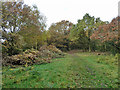
Path with recent scrub clearance
This area is an isolated scrap of Epping Forest.
Image: © Robin Webster
Taken: 17 Nov 2012
0.15 miles
9
View of King George's Reservoir from the London LOOP
The London LOOP heads uphill from Daws Hill to pass near the top of Barn Hill. On the way up this provides fine views across the Lea Valley. In this photograph on a misty early autumn day after a foggy start King George's Reservoir can be seen below.
For King George's Reservoir, the excavation and building of the surrounding embankment of the reservoir, nearly five miles in length, was carried out almost entirely by a manual labour force of 1,000 navvies, and the surplus excavated clay was spread over part of Hackney Marsh. In 1913 King George Vth and Queen Mary named the reservoir and pressed the buttons allowing water from the River Lea to start flowing into the storage bowl.
Image: © Marathon
Taken: 27 Sep 2017
0.20 miles
10
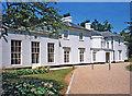
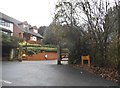
Gilwell Park, Chingford, Essex
Gilwell Park is a conference centre owned by the Scout Association.
http://www2.scouts.org.uk/conferencecentre/
Image: © Christine Matthews
Taken: Unknown
0.23 miles