IMAGES TAKEN NEAR TO
The Ridgeway, LONDON, E4 6UG
Introduction
This page details the photographs taken nearby to The Ridgeway, E4 6UG by members of the Geograph project.
The Geograph project started in 2005 with the aim of publishing, organising and preserving representative images for every square kilometre of Great Britain, Ireland and the Isle of Man.

There are currently over 7.5m images from over14,400 individuals and you can help contribute to the project by visiting https://www.geograph.org.uk
Image Map
Images are licensed for reuse under creativecommons.org/licenses/by-sa/2.0
Notes
- Clicking on the map will re-center to the selected point.
- The higher the marker number, the further away the image location is from the centre of the postcode.
Image Listing (109 Images Found)
Images are licensed for reuse under creativecommons.org/licenses/by-sa/2.0
Image
Details
Distance
1
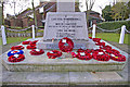
Chingford War Memorial, London E4
Image: © Christine Matthews
Taken: 18 Nov 2008
0.00 miles
3
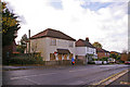
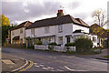
Kings Head Hill (A110) , Chingford, London E4
Looking across Kings Head Hill we have what looks to me (though I may be mistaken) to be a pair of newish houses built in the old style next to a pair of genuine old clapboard cottages.
Image: © Christine Matthews
Taken: 18 Nov 2008
0.02 miles
4
Houses, Kings Head Hill, London E4
Wooden clapboard houses in Kings Head Hill as seen from outside Sunnyside Lodge.
Image: © Christine Matthews
Taken: 18 Nov 2008
0.02 miles
5
Kings Head Hill (A110) , Chingford, London E4
Looking down Kings Head Hill from the junction with Parkhill Road, The Green and The Ridgeway. The war memorial is to the left just outside the image.
Image: © Christine Matthews
Taken: 18 Nov 2008
0.03 miles
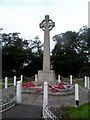
6
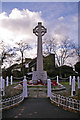
Chingford War Memorial, London E4
Chingford War Memorial as seen from The Ridgeway.
Image: © Christine Matthews
Taken: 18 Nov 2008
0.03 miles
8
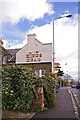
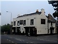
The Kings Head, Chingford, London E4
The Kings Head as seen from Kings Head Hill not far from the junction with Woodberry Way.
Image: © Christine Matthews
Taken: 18 Nov 2008
0.04 miles
9
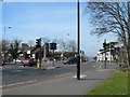
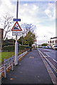
Junction of The Green, Kings Head Hill and The Ridgeway, Chingford
The Police Station is out of view, on the right.
Image: © Danny P Robinson
Taken: 6 Apr 2007
0.04 miles