IMAGES TAKEN NEAR TO
St. Egbert's Way, LONDON, E4 6QH
Introduction
This page details the photographs taken nearby to St. Egbert's Way, E4 6QH by members of the Geograph project.
The Geograph project started in 2005 with the aim of publishing, organising and preserving representative images for every square kilometre of Great Britain, Ireland and the Isle of Man.

There are currently over 7.5m images from over14,400 individuals and you can help contribute to the project by visiting https://www.geograph.org.uk
Image Map (Loading...)


Getting Data...Please wait
Leaflet Map data © OpenStreetMap
Images are licensed for reuse under creativecommons.org/licenses/by-sa/2.0
Notes
- Clicking on the map will re-center to the selected point.
- The higher the marker number, the further away the image location is from the centre of the postcode.
Image Listing (111 Images Found)
Images are licensed for reuse under creativecommons.org/licenses/by-sa/2.0
Image
Details
Distance
1
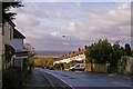
Kings Head Hill (A110), Chingford, London E4
Looking down Kings Head Hill towards the reservoirs.
Image: © Christine Matthews
Taken: 18 Nov 2008
0.03 miles
2
Kings Head Hill (A110) , Chingford, London E4
Looking down Kings Head Hill towards the reservoirs.
Image: © Christine Matthews
Taken: 18 Nov 2008
0.04 miles
3
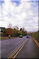
Traffic queuing below the roadworks on Kings Head Hill
Only one side of the road is open, controlled by traffic lights.
Image: © Christine Johnstone
Taken: 11 Jan 2016
0.05 miles
4
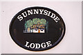
House name plaque "Sunnyside Lodge"
Image: © Christine Matthews
Taken: 18 Nov 2008
0.07 miles
5
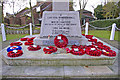
Chingford War Memorial, London E4
Image: © Christine Matthews
Taken: 18 Nov 2008
0.07 miles
6
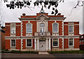
Former Chingford Town Hall
Built in 1929 to the designs of architects Frederick Nash and H.T. Bonner. Information extracted from: The Buildings of England. London 5: East. New Haven, London : Yale University Press, 2005, p. 716. Converted into residential accommodation.
Image: © Jim Osley
Taken: 3 Feb 2016
0.07 miles
7
Sunnyside Lodge, Woodberry Way, London E4
Sunnyside Lodge was the former Gatekeeper's Lodge to "Sunnyside", a substantial mid 19th century house of 10 bedrooms, over the site of which Woodberry Way and Sunnyside Drive were laid out in the 1920s and 1930s. Image] Image]
Image: © Christine Matthews
Taken: 18 Nov 2008
0.07 miles
8
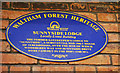
Plaque on Sunnyside Lodge erected by Waltham Forest Heritage
Plaque erected by Waltham Forest Heritage for a locally listed building on Sunnyside Lodge, which was the former Gatekeeper's Lodge to "Sunnyside", a substantial mid 19th century house of 10 bedrooms, over the site of which Woodberry Way and Sunnyside Drive were laid out in the 1920s and 1930s
Image: © Christine Matthews
Taken: 18 Nov 2008
0.07 miles
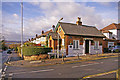
10
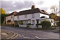
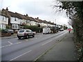
Houses, Kings Head Hill, London E4
Wooden clapboard houses in Kings Head Hill as seen from outside Sunnyside Lodge.
Image: © Christine Matthews
Taken: 18 Nov 2008
0.07 miles