IMAGES TAKEN NEAR TO
The Bramblings, LONDON, E4 6LT
Introduction
This page details the photographs taken nearby to The Bramblings, E4 6LT by members of the Geograph project.
The Geograph project started in 2005 with the aim of publishing, organising and preserving representative images for every square kilometre of Great Britain, Ireland and the Isle of Man.

There are currently over 7.5m images from over14,400 individuals and you can help contribute to the project by visiting https://www.geograph.org.uk
Image Map
Images are licensed for reuse under creativecommons.org/licenses/by-sa/2.0
Notes
- Clicking on the map will re-center to the selected point.
- The higher the marker number, the further away the image location is from the centre of the postcode.
Image Listing (39 Images Found)
Images are licensed for reuse under creativecommons.org/licenses/by-sa/2.0
Image
Details
Distance
1
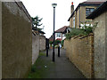
Alley from Balliol Avenue to The Bramblings
This saved me retracing my steps when I realized that The Bramblings (glimpsed at the end) had no road connection to the south.
Image: © Robin Webster
Taken: 20 Oct 2012
0.04 miles
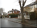
2
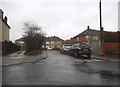
The Ramblings at the junction of Balliol Avenue
Image: © David Howard
Taken: 20 Jan 2018
0.06 miles
5
Petrol station on Hatch Lane, Chingford
Image: © David Howard
Taken: 20 Jan 2018
0.12 miles
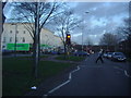
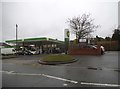
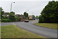
7
Roundabout and River, Chingford Hatch
Roundabout on A1009 at Chingford Hatch, London E4, with River Ching running through the middle, looking north-east.
Image: © John Davies
Taken: 18 Dec 2005
0.15 miles
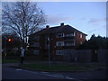
8
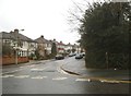
The Avenue at the junction of Waterhall Avenue
Image: © David Howard
Taken: 20 Jan 2018
0.15 miles
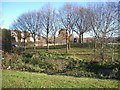
10
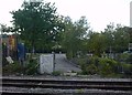
The Site of Chingford Hatch Level Crossing
The opproach to what was Chingford Hatch Level Crossing which was closed in 1971.
The closure severed Hatch Lane in two. This shot was taken on the easterly side in Hatch Lane. See photo Image for a shot from the other side of the track.
Image: © Richard Dunn
Taken: Unknown
0.18 miles