IMAGES TAKEN NEAR TO
Ashwood Road, LONDON, E4 6LG
Introduction
This page details the photographs taken nearby to Ashwood Road, E4 6LG by members of the Geograph project.
The Geograph project started in 2005 with the aim of publishing, organising and preserving representative images for every square kilometre of Great Britain, Ireland and the Isle of Man.

There are currently over 7.5m images from over14,400 individuals and you can help contribute to the project by visiting https://www.geograph.org.uk
Image Map
Images are licensed for reuse under creativecommons.org/licenses/by-sa/2.0
Notes
- Clicking on the map will re-center to the selected point.
- The higher the marker number, the further away the image location is from the centre of the postcode.
Image Listing (32 Images Found)
Images are licensed for reuse under creativecommons.org/licenses/by-sa/2.0
Image
Details
Distance
3
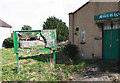
Uniting Church, Connington Crescent, Chingford Hatch - Nitice board
Derelict church
Image: © John Salmon
Taken: 14 Mar 2011
0.10 miles
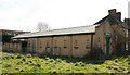
4
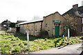
Uniting Church, Connington Crescent, Chingford Hatch
Derelict church
Image: © John Salmon
Taken: 14 Mar 2011
0.10 miles
5
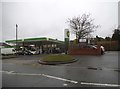
Petrol station on Hatch Lane, Chingford
Image: © David Howard
Taken: 20 Jan 2018
0.11 miles
6
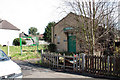
Uniting Church, Connington Crescent, Chingford Hatch
Image: © John Salmon
Taken: 14 Mar 2011
0.11 miles
7
Uniting Church, Connington Crescent, Chingford Hatch
Derelict church
Image: © John Salmon
Taken: 14 Mar 2011
0.12 miles
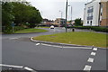
8
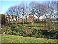
Roundabout and River, Chingford Hatch
Roundabout on A1009 at Chingford Hatch, London E4, with River Ching running through the middle, looking north-east.
Image: © John Davies
Taken: 18 Dec 2005
0.14 miles