IMAGES TAKEN NEAR TO
Wittenham Way, LONDON, E4 6JP
Introduction
This page details the photographs taken nearby to Wittenham Way, E4 6JP by members of the Geograph project.
The Geograph project started in 2005 with the aim of publishing, organising and preserving representative images for every square kilometre of Great Britain, Ireland and the Isle of Man.

There are currently over 7.5m images from over14,400 individuals and you can help contribute to the project by visiting https://www.geograph.org.uk
Image Map (Loading...)


Getting Data...Please wait
Leaflet Map data © OpenStreetMap
Images are licensed for reuse under creativecommons.org/licenses/by-sa/2.0
Notes
- Clicking on the map will re-center to the selected point.
- The higher the marker number, the further away the image location is from the centre of the postcode.
Image Listing (17 Images Found)
Images are licensed for reuse under creativecommons.org/licenses/by-sa/2.0
Image
Details
Distance
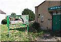
1
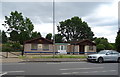
Chingford Horticultural Society
On Larkshall Road.
Image: © JThomas
Taken: 6 Jul 2019
0.11 miles
2
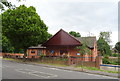
Kingdom Hall of Jehovah's Witnesses, Chingford
On Larkshall Road.
Image: © JThomas
Taken: 6 Jul 2019
0.11 miles
4
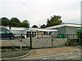
Scope, Chingford Centre
For people with cerebral palsy, on Weale Road.
Image: © Robin Webster
Taken: 20 Oct 2012
0.16 miles
7
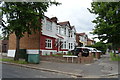
The Sirloin, Friday Hill
One of the blackboards says "Poland v England Tuesday" and is thus four days out of date. The other says "Kenny Thomas canceled collect money by Sunday".
Image: © Robin Webster
Taken: 20 Oct 2012
0.21 miles
9
Uniting Church, Connington Crescent, Chingford Hatch - Nitice board
Derelict church
Image: © John Salmon
Taken: 14 Mar 2011
0.22 miles
10
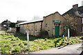
Uniting Church, Connington Crescent, Chingford Hatch
Derelict church
Image: © John Salmon
Taken: 14 Mar 2011
0.23 miles