IMAGES TAKEN NEAR TO
Newgate Street, LONDON, E4 6JF
Introduction
This page details the photographs taken nearby to Newgate Street, E4 6JF by members of the Geograph project.
The Geograph project started in 2005 with the aim of publishing, organising and preserving representative images for every square kilometre of Great Britain, Ireland and the Isle of Man.

There are currently over 7.5m images from over14,400 individuals and you can help contribute to the project by visiting https://www.geograph.org.uk
Image Map (Loading...)


Getting Data...Please wait
Leaflet Map data © OpenStreetMap
Images are licensed for reuse under creativecommons.org/licenses/by-sa/2.0
Notes
- Clicking on the map will re-center to the selected point.
- The higher the marker number, the further away the image location is from the centre of the postcode.
Image Listing (42 Images Found)
Images are licensed for reuse under creativecommons.org/licenses/by-sa/2.0
Image
Details
Distance

8
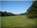
View of Chingford Hatch from Woodford Golf Course
Looking north-northwest.
Image: © Robert Lamb
Taken: 14 Oct 2012
0.09 miles
9
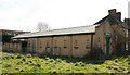
Uniting Church, Connington Crescent, Chingford Hatch
Derelict church
Image: © John Salmon
Taken: 14 Mar 2011
0.09 miles
10
Uniting Church, Connington Crescent, Chingford Hatch
Image: © John Salmon
Taken: 14 Mar 2011
0.10 miles