IMAGES TAKEN NEAR TO
Wyemead Crescent, LONDON, E4 6HN
Introduction
This page details the photographs taken nearby to Wyemead Crescent, E4 6HN by members of the Geograph project.
The Geograph project started in 2005 with the aim of publishing, organising and preserving representative images for every square kilometre of Great Britain, Ireland and the Isle of Man.

There are currently over 7.5m images from over14,400 individuals and you can help contribute to the project by visiting https://www.geograph.org.uk
Image Map
Images are licensed for reuse under creativecommons.org/licenses/by-sa/2.0
Notes
- Clicking on the map will re-center to the selected point.
- The higher the marker number, the further away the image location is from the centre of the postcode.
Image Listing (9 Images Found)
Images are licensed for reuse under creativecommons.org/licenses/by-sa/2.0
Image
Details
Distance
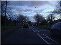
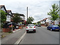
1

Mini roundabout on Whitehall Road, Chingford
Image: © David Howard
Taken: 5 Jan 2012
0.09 miles
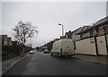
8
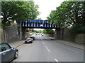
Railway bridge over King's Road (A110), Chingford
Image: © JThomas
Taken: 6 Jul 2019
0.24 miles
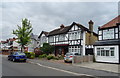
9
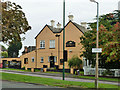
The Sirloin, Friday Hill
One of the blackboards says "Poland v England Tuesday" and is thus four days out of date. The other says "Kenny Thomas canceled collect money by Sunday".
Image: © Robin Webster
Taken: 20 Oct 2012
0.24 miles