IMAGES TAKEN NEAR TO
Viking Close, LONDON, E3 5RL
Introduction
This page details the photographs taken nearby to Viking Close, E3 5RL by members of the Geograph project.
The Geograph project started in 2005 with the aim of publishing, organising and preserving representative images for every square kilometre of Great Britain, Ireland and the Isle of Man.

There are currently over 7.5m images from over14,400 individuals and you can help contribute to the project by visiting https://www.geograph.org.uk
Image Map (Loading...)


Getting Data...Please wait
Leaflet Map data © OpenStreetMap
Images are licensed for reuse under creativecommons.org/licenses/by-sa/2.0
Notes
- Clicking on the map will re-center to the selected point.
- The higher the marker number, the further away the image location is from the centre of the postcode.
Image Listing (96 Images Found)
Images are licensed for reuse under creativecommons.org/licenses/by-sa/2.0
Image
Details
Distance
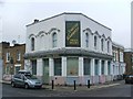
6
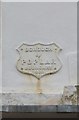
The Poor Old Duke Of York
Another view of this street corner pub. (see also Image)
Just visible on the wall between the bottom of the Smith Garrett sign and the window is a small shield shaped sign which is a boundary marker for the old Borough of Poplar.
Image: © Des Blenkinsopp
Taken: 11 Feb 2016
0.06 miles
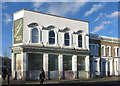
9
Old Boundary Marker by Selwyn Road, Bow Road parish
Municipal Boundary Marker by the UC road, in parish of Bow (Tower Hamlets District), Selwyn Road E3, corner with Antill Road, high on wall of former Duke of York PH.
Surveyed
Milestone Society National ID: MX_POPL04pb
Image: © Milestone Society
Taken: Unknown
0.06 miles
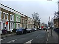
10
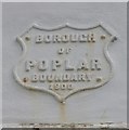
Old Boundary Marker by Antill Road, Bow parish
Municipal Boundary Marker by the UC road, in parish of Bow (Tower Hamlets District), Antill Street E3, corner with Selwyn Road, high on wall of former Duke of York PH.
Inscription reads:-
BOROUGH
OF
POPLAR
BOUNDARY
1900
Surveyed
Milestone Society National ID: MX_POPL03pb
Image: © Milestone Society
Taken: Unknown
0.06 miles