IMAGES TAKEN NEAR TO
Roman Road, LONDON, E3 5QR
Introduction
This page details the photographs taken nearby to Roman Road, E3 5QR by members of the Geograph project.
The Geograph project started in 2005 with the aim of publishing, organising and preserving representative images for every square kilometre of Great Britain, Ireland and the Isle of Man.

There are currently over 7.5m images from over14,400 individuals and you can help contribute to the project by visiting https://www.geograph.org.uk
Image Map (Loading...)


Getting Data...Please wait
Leaflet Map data © OpenStreetMap
Images are licensed for reuse under creativecommons.org/licenses/by-sa/2.0
Notes
- Clicking on the map will re-center to the selected point.
- The higher the marker number, the further away the image location is from the centre of the postcode.
Image Listing (257 Images Found)
Images are licensed for reuse under creativecommons.org/licenses/by-sa/2.0
Image
Details
Distance
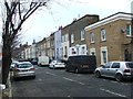
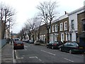
2
Kenilworth Road, E3
Looking towards Roman Road.
Image: © Robin Webster
Taken: 6 Apr 2019
0.04 miles
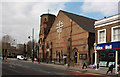
4
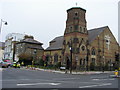
St Barnabas
St Barnabas parish church on Grove road
Image: © Shaun Ferguson
Taken: 24 Sep 2008
0.04 miles
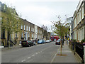
6

Roman Road, Bow
The B119 east of its junction with Grove Road. Gernon Road leads off to the right.
Image: © Stephen McKay
Taken: 9 Oct 2015
0.04 miles
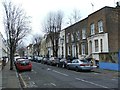
7
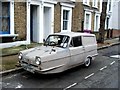
Reliant Regal Supervan, Zealand Road, Bow
Image: © Chris Whippet
Taken: 4 Jan 2015
0.05 miles
9
St Barnabas, Grove Road, Bethnal Green - Foundation stone
Image: © John Salmon
Taken: 1 Dec 2017
0.05 miles
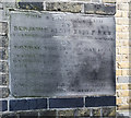
10
St Barnabas, Grove Road, Bethnal Green - War Memorial Brass
Image: © John Salmon
Taken: 1 Dec 2017
0.05 miles