IMAGES TAKEN NEAR TO
Stafford Road, LONDON, E3 5EZ
Introduction
This page details the photographs taken nearby to Stafford Road, E3 5EZ by members of the Geograph project.
The Geograph project started in 2005 with the aim of publishing, organising and preserving representative images for every square kilometre of Great Britain, Ireland and the Isle of Man.

There are currently over 7.5m images from over14,400 individuals and you can help contribute to the project by visiting https://www.geograph.org.uk
Image Map (63 Images)


Getting Data...Please wait
Leaflet Map data © OpenStreetMap
Images are licensed for reuse under creativecommons.org/licenses/by-sa/2.0
Notes
- Clicking on the map will re-center to the selected point.
- The higher the marker number, the further away the image location is from the centre of the postcode.
Image Listing (63 Images Found)
Images are licensed for reuse under creativecommons.org/licenses/by-sa/2.0
Image
Details
Distance
2
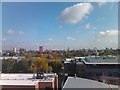
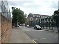
View of the Stratford Olympic Village from Queen Mary, University of London
Taken from a lecture room on the 6th floor of the GO Jones building. The stadium can be seen straight ahead in the centre of the image.
Image: © Robert Lamb
Taken: 19 Sep 2011
0.10 miles
8
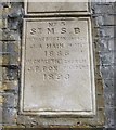
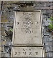
Old Boundary Marker by Coburn Road, Bow Parish
Parish Boundary Marker by the UC road, in parish of Bow (Tower Hamlets District), Coborn Road E3, on railway bridge abutment below: MX_SMSB01pb Image
Surveyed
Milestone Society National ID: MX_SMSB02pb
Image: © Milestone Society
Taken: Unknown
0.13 miles
9
Old Boundary Marker by Coburn Road, Bow Parish
Parish Boundary Marker by the UC road, in parish of Bow (Tower Hamlets District), Coborn Road E3, on railway bridge abutment above: MX_SMSB02pb. Image
Surveyed
Milestone Society National ID: MX_SMSB01pb
Image: © Milestone Society
Taken: Unknown
0.13 miles
10
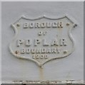
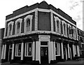
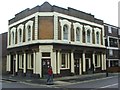
Old Boundary Marker by Selwyn Road, Bow Road parish
Municipal Boundary Marker by the UC road, in parish of Bow (Tower Hamlets District), Selwyn Road E3, corner with Antill Road, high on wall of former Duke of York PH.
Surveyed
Milestone Society National ID: MX_POPL04pb
Image: © Milestone Society
Taken: Unknown
0.14 miles