IMAGES TAKEN NEAR TO
Tidworth Road, LONDON, E3 4XH
Introduction
This page details the photographs taken nearby to Tidworth Road, E3 4XH by members of the Geograph project.
The Geograph project started in 2005 with the aim of publishing, organising and preserving representative images for every square kilometre of Great Britain, Ireland and the Isle of Man.

There are currently over 7.5m images from over14,400 individuals and you can help contribute to the project by visiting https://www.geograph.org.uk
Image Map
Images are licensed for reuse under creativecommons.org/licenses/by-sa/2.0
Notes
- Clicking on the map will re-center to the selected point.
- The higher the marker number, the further away the image location is from the centre of the postcode.
Image Listing (161 Images Found)
Images are licensed for reuse under creativecommons.org/licenses/by-sa/2.0
Image
Details
Distance
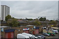
3
Bow Business Centre
Beyond the caravans and cabins of the business centre, a tube train on the District Line heads from Bromley-by-Bow towards Bow Road.
Image: © John Allan
Taken: 29 Apr 2013
0.07 miles
5
Tomlin's Grove, Bow
Looking towards the junction with Arnold Road. This is part of the Tomlin's Grove conservation area.
Image: © Stephen McKay
Taken: 11 Jun 2015
0.08 miles
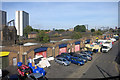
6
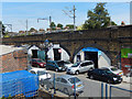
Arnold Road, Bow
Looking down from the footbridge over the District Line to car repair and servicing businesses operating in the railway arches. The line above the arches runs from Gas Factory Junction, on the main line out of Fenchurch Street, and Bow Junction, on the main line out of Liverpool Street.
Image: © Stephen McKay
Taken: 11 Jun 2015
0.08 miles
9
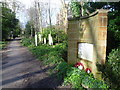
Memorial in Tower Hamlets Cemetery to the people of Poplar killed in air raids
Tower Hamlets Cemetery was built by the Victorians as a model necropolis in 1841. It was one of "The Magnificent Seven" cemeteries opened around that time to relieve pressure on London's overcrowded churchyards. The other six were Abney Park, Highgate, Kensal Green, Brompton, Norwood and Nunhead. It was consecrated on 4th September 1841, the date that the first interment was made. Tower Hamlets was initially a financial success and by 1889 some 250,000 bodies had been buried, the vast majority in common graves. Over the next 75 years the cemetery faced the same problem as many other Victorian cemeteries of increasing cost of maintenance coupled with reduced income from burials. Burials at Tower Hamlets ceased in 1966.
This is the only sizeable, established woodland in the Borough of Tower Hamlets. Over the last 25 years it has been developed as a cemetery park and now makes a fine nature reserve which is popular with local people.
This memorial is next to the path along the eastern side of the Cemetery. It says "THIS GARDEN COMMEMORATES THE LIVES OF 190 PEOPLE OF POPLAR WHO WERE AMONG THOSE KILLED IN AIR RAIDS IN THIS BOROUGH DURING THE SECOND WORLD WAR 1939 - 1945 AND WHOSE MORTAL REMAINS REST IN THIS PLACE". Its detail can be seen at http://www.geograph.org.uk/photo/3869008
Image: © Marathon
Taken: 26 Feb 2014
0.10 miles
10
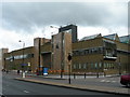
Thames Magistrates Court
This court is on Bow Road, E3, at the corner with Mornington Grove.
Image: © Danny P Robinson
Taken: 13 May 2007
0.11 miles