IMAGES TAKEN NEAR TO
Mile End Road, LONDON, E3 4PB
Introduction
This page details the photographs taken nearby to Mile End Road, E3 4PB by members of the Geograph project.
The Geograph project started in 2005 with the aim of publishing, organising and preserving representative images for every square kilometre of Great Britain, Ireland and the Isle of Man.

There are currently over 7.5m images from over14,400 individuals and you can help contribute to the project by visiting https://www.geograph.org.uk
Image Map
Images are licensed for reuse under creativecommons.org/licenses/by-sa/2.0
Notes
- Clicking on the map will re-center to the selected point.
- The higher the marker number, the further away the image location is from the centre of the postcode.
Image Listing (358 Images Found)
Images are licensed for reuse under creativecommons.org/licenses/by-sa/2.0
Image
Details
Distance
4
Hindu Pragati Saja Mandir
Rhondda Grove - E3.
Image: © Fernweh
Taken: 17 May 2012
0.01 miles
6
Bow, temple
Hindu Pragati Sangha Mandir, on Rhondda Grove E3. http://hindupragatisangha.net/
Image: © Mike Faherty
Taken: 26 Aug 2012
0.02 miles
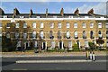
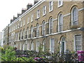
8

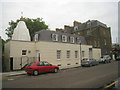
Terraces on Bow Road
Smart Georgian terraces on the north side of Bow Road. The junction is with Tredegar Square.
Image: © Derek Harper
Taken: 1 Feb 2011
0.03 miles
9
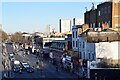
Mile End
Looking down on Mile End Road, including Mile End Station.
Taken from the foot and cycle bridge connecting the north and south sections of Mile End Park.
Image: © Trevor Harris
Taken: 27 Feb 2022
0.03 miles