IMAGES TAKEN NEAR TO
Tomlins Grove, LONDON, E3 4NX
Introduction
This page details the photographs taken nearby to Tomlins Grove, E3 4NX by members of the Geograph project.
The Geograph project started in 2005 with the aim of publishing, organising and preserving representative images for every square kilometre of Great Britain, Ireland and the Isle of Man.

There are currently over 7.5m images from over14,400 individuals and you can help contribute to the project by visiting https://www.geograph.org.uk
Image Map
Images are licensed for reuse under creativecommons.org/licenses/by-sa/2.0
Notes
- Clicking on the map will re-center to the selected point.
- The higher the marker number, the further away the image location is from the centre of the postcode.
Image Listing (191 Images Found)
Images are licensed for reuse under creativecommons.org/licenses/by-sa/2.0
Image
Details
Distance
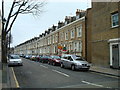
1
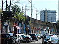
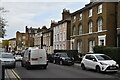
Tomlin's Grove, Bow
Part of the Tomlin's Grove conservation area, designated by the Borough of Tower Hamlets in 1969, this listed terrace dates from the late 19th century.
Image: © Stephen McKay
Taken: 11 Jun 2015
0.02 miles
2
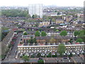
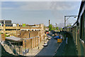
View from Mallard House
View westwards from Mallard House towards the City of London. In the foreground is Campbell Road.
Image: © Malc McDonald
Taken: 1 May 2010
0.03 miles
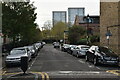
4
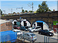
Arnold Road, Bow
Looking down from the footbridge over the District Line to car repair and servicing businesses operating in the railway arches. The line above the arches runs from Gas Factory Junction, on the main line out of Fenchurch Street, and Bow Junction, on the main line out of Liverpool Street.
Image: © Stephen McKay
Taken: 11 Jun 2015
0.03 miles
5
Arnold Road, Bow
Looking south from Bow Road; Arnold Road hugs the railway viaduct carrying the link line between Gas Factory Junction and Bow Junction. There are car repairs and servicing businesses here operating under the arches.
Image: © Stephen McKay
Taken: 11 Jun 2015
0.05 miles
6
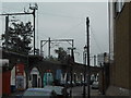
Steaming through Bow
76079 heads a down "Cockney Coaster" on the little-used viaduct link between Limehouse and Stratford. The street below is Arnold Road. The steps at left serve a footbridge over the District Line, which here passes under the viewpoint on its ramp down underground east of Bow Road station.
Image: © Robin Webster
Taken: 7 May 2001
0.05 miles
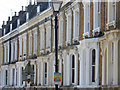
8
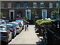
Tomlin's Grove, Bow
Looking towards the junction with Arnold Road. This is part of the Tomlin's Grove conservation area.
Image: © Stephen McKay
Taken: 11 Jun 2015
0.06 miles