IMAGES TAKEN NEAR TO
Eric Street, LONDON, E3 4JL
Introduction
This page details the photographs taken nearby to Eric Street, E3 4JL by members of the Geograph project.
The Geograph project started in 2005 with the aim of publishing, organising and preserving representative images for every square kilometre of Great Britain, Ireland and the Isle of Man.

There are currently over 7.5m images from over14,400 individuals and you can help contribute to the project by visiting https://www.geograph.org.uk
Image Map (Loading...)


Getting Data...Please wait
Leaflet Map data © OpenStreetMap
Images are licensed for reuse under creativecommons.org/licenses/by-sa/2.0
Notes
- Clicking on the map will re-center to the selected point.
- The higher the marker number, the further away the image location is from the centre of the postcode.
Image Listing (171 Images Found)
Images are licensed for reuse under creativecommons.org/licenses/by-sa/2.0
Image
Details
Distance
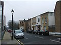
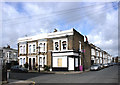
2
Former doctor's surgery in Bethnal Green
This building on the corner of Bow Common Lane and Eric Street was formerly a doctor's surgery. It is shown on OS maps as 208 Bow Common Lane and listed in London Directories as follows:-.
1901 Carrigan Ewd. MB physician
1921 Kiddle Horace Harvard, physician & surgeon.
1950s Doctors Surgery see https://www.ideastore.co.uk/digital-gallery/view/94
This information was supplied by Victor Smith.
Eric Street, which is the road ahead on the left, was once the location of the snooker hall (The Regal) that belonged to the Krays. It has since then been demolished.
Image: © Marathon
Taken: 26 Feb 2014
0.03 miles
4
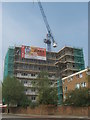
Bow Trinity, Bow
New housing block on Portia Way. As seen from Burdett Road.
Image: © David Anstiss
Taken: 23 May 2012
0.05 miles
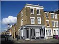
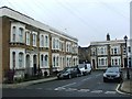
5
Eric Street Corner shop (Closed)
On the corner of Eric St. and Mossford St.
Groovy lilac wheely bins they have round here.
Image: © Des Blenkinsopp
Taken: 10 Mar 2011
0.06 miles
7
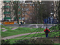
Skateboard or BMX track?
This facility in Mile End Park looks as if it is intended for skateboarders, but one not-so-young BMX rider was taking advantage of it.
Image: © Stephen Craven
Taken: 11 Jan 2015
0.06 miles
8
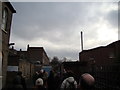
View of One Canada Square and the hospital chimney from the St Clement's Hospital site
Looking south-southwest. If you're wondering how I got access into the site (the site has been closed to the public since 2005), I have two friends from university who are working on a project to convert the hospital site into a Community Land Trust, passed by Boris Johnson last year. Read more about it here: http://www.jtp.co.uk/community-planning-projects/st-clements/
Image: © Robert Lamb
Taken: 1 Dec 2012
0.06 miles
9
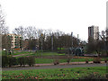
Playground, Mile End Park
Adventure play area.
Image: © Stephen Craven
Taken: 11 Jan 2015
0.07 miles
10
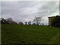
View of Canary Wharf from the Regent's Canal towpath
Looking south-southeast.
Image: © Robert Lamb
Taken: 24 Apr 2012
0.07 miles