IMAGES TAKEN NEAR TO
Joseph Street, LONDON, E3 4GZ
Introduction
This page details the photographs taken nearby to Joseph Street, E3 4GZ by members of the Geograph project.
The Geograph project started in 2005 with the aim of publishing, organising and preserving representative images for every square kilometre of Great Britain, Ireland and the Isle of Man.

There are currently over 7.5m images from over14,400 individuals and you can help contribute to the project by visiting https://www.geograph.org.uk
Image Map (Loading...)


Getting Data...Please wait
Leaflet Map data © OpenStreetMap
Images are licensed for reuse under creativecommons.org/licenses/by-sa/2.0
Notes
- Clicking on the map will re-center to the selected point.
- The higher the marker number, the further away the image location is from the centre of the postcode.
Image Listing (99 Images Found)
Images are licensed for reuse under creativecommons.org/licenses/by-sa/2.0
Image
Details
Distance
1
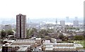
View South from high rise flats, Bow Common Lane , Bow
Photographed before the re-development of the Isle of Dogs. The horizon would now be showing modern steel and glass sky-scrapers. Also shown at lower centre is the Burdett Road rail bridge that was shortly to be demolished and replaced with one to span the planned widened road. Image See also just off the centre of picture, Hawksmoor's White tower atop St Anne's church in Limehouse.
Image: © Derek Voller
Taken: Unknown
0.02 miles
2
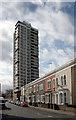
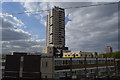
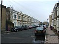
Maritime Street and Lewey House
Old and new housing.
Lewey house was built in 1966 and is 74 m high.
Image: © Des Blenkinsopp
Taken: 10 Mar 2011
0.02 miles
7

View of Canary Wharf from Mile End Park
With the tennis courts in the centre of the photograph. Looking south-southeast.
Image: © Robert Lamb
Taken: 24 Aug 2010
0.08 miles
8
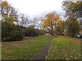
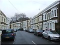
Public space and footpath near Ackroyd Drive
The narrow stretch between Ackroyd Drive and the railway has been made into a public open space. A path crosses the grassy sections, and one part is a small allotment
Image: © David Smith
Taken: 20 Nov 2012
0.08 miles
10
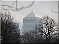
Zoom in on One Canada Square from the St Clement's Hospital site
Looking south-southwest. If you're wondering how I got access into the site (the site has been closed to the public since 2005), I have two friends from university who are working on a project to convert the hospital site into a Community Land Trust, passed by Boris Johnson last year. Read more about it here: http://www.jtp.co.uk/community-planning-projects/st-clements/
Image: © Robert Lamb
Taken: 1 Dec 2012
0.09 miles