IMAGES TAKEN NEAR TO
Hamlets Way, LONDON, E3 4GS
Introduction
This page details the photographs taken nearby to Hamlets Way, E3 4GS by members of the Geograph project.
The Geograph project started in 2005 with the aim of publishing, organising and preserving representative images for every square kilometre of Great Britain, Ireland and the Isle of Man.

There are currently over 7.5m images from over14,400 individuals and you can help contribute to the project by visiting https://www.geograph.org.uk
Image Map (Loading...)


Getting Data...Please wait
Leaflet Map data © OpenStreetMap
Images are licensed for reuse under creativecommons.org/licenses/by-sa/2.0
Notes
- Clicking on the map will re-center to the selected point.
- The higher the marker number, the further away the image location is from the centre of the postcode.
Image Listing (247 Images Found)
Images are licensed for reuse under creativecommons.org/licenses/by-sa/2.0
Image
Details
Distance
1
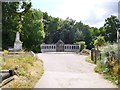
Bow, war memorial
A polished granite wall honouring the dead of two World Wars; in Tower Hamlets Cemetery Park.
Image: © Mike Faherty
Taken: 26 Aug 2012
0.03 miles
2
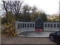
War memorial in Tower Hamlets Cemetery Park
Image: © David Smith
Taken: 20 Nov 2012
0.04 miles
4
View of Canary Wharf from Brokesley Street
Looking south-southeast.
Image: © Robert Lamb
Taken: 1 Dec 2012
0.07 miles
5
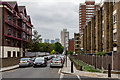
View of Rebecca House and Windermere House from the St Clement's Hospital site
Looking south-southwest. If you're wondering how I got access into the site (the site has been closed to the public since 2005), I have two friends from university who are working on a project to convert the hospital site into a Community Land Trust, passed by Boris Johnson last year. Read more about it here: http://www.jtp.co.uk/community-planning-projects/st-clements/
Image: © Robert Lamb
Taken: 1 Dec 2012
0.08 miles
6
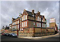
Avery Hill College (Mile End Annexe), Ropery Street
Ropery Street is a memory of one of the many industries formerly round here associated with London Docks.
Update:- Ronald Applegate who was a pupil here 1943 - 48 tells me this was then Southern Grove School. Thanks Ronald.
Image: © Des Blenkinsopp
Taken: 10 Mar 2011
0.08 miles
7
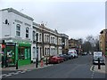
Southern Grove
A general view of this street with the towering office blocks of Canary Wharf visible in the distance.
Image: © Martin Addison
Taken: 15 May 2015
0.08 miles
9
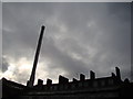
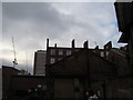
View of the hospital chimney and Rebecca House from the St Clement's Hospital site
Looking south-southwest. If you're wondering how I got access into the site (the site has been closed to the public since 2005), I have two friends from university who are working on a project to convert the hospital site into a Community Land Trust, passed by Boris Johnson last year. Read more about it here: http://www.jtp.co.uk/community-planning-projects/st-clements/
Image: © Robert Lamb
Taken: 1 Dec 2012
0.09 miles
10
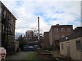
View of the hospital chimney from the St Clement's Hospital drive
Looking south-southwest. If you're wondering how I got access into the site (the site has been closed to the public since 2005), I have two friends from university who are working on a project to convert the hospital site into a Community Land Trust, passed by Boris Johnson last year. Read more about it here: http://www.jtp.co.uk/community-planning-projects/st-clements/
Image: © Robert Lamb
Taken: 1 Dec 2012
0.09 miles